You are here: Home > Network List > RV - Regional Alberta Seismic Observatory for Earthquake Studies Network Stations List
> Station HSPGA Hill Springs, AB > Earthquake Result Viewer
HSPGA Hill Springs, AB - Earthquake Result Viewer
| Earthquake location: |
Near Islands, Aleutian Islands |
| Earthquake latitude/longitude: |
54.0/170.9 |
| Earthquake time(UTC): |
2017/06/02 (153) 22:24:47 GMT |
| Earthquake Depth: |
8.2 km |
| Earthquake Magnitude: |
6.8 Mww |
| Earthquake Catalog/Contributor: |
NEIC PDE/us |
|
| Network: |
RV Regional Alberta Seismic Observatory for Earthquake Studies Network |
| Station: |
HSPGA Hill Springs, AB |
| Lat/Lon: |
49.36 N/113.65 W |
| Elevation: |
1155 m |
|
| Distance: |
44.9 deg |
| Az: |
63.635 deg |
| Baz: |
306.055 deg |
| Ray Param: |
0.07161574 |
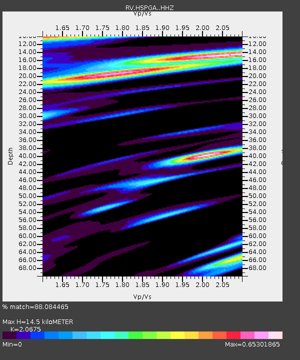
| Estimated Moho Depth: |
14.5 km |
| Estimated Crust Vp/Vs: |
2.07 |
| Assumed Crust Vp: |
6.178 km/s |
| Estimated Crust Vs: |
2.988 km/s |
| Estimated Crust Poisson's Ratio: |
0.35 |
|
| Radial Match: |
88.084465 % |
| Radial Bump: |
400 |
| Transverse Match: |
71.642494 % |
| Transverse Bump: |
400 |
| SOD ConfigId: |
13570011 |
| Insert Time: |
2019-04-28 03:15:20.714 +0000 |
| GWidth: |
2.5 |
| Max Bumps: |
400 |
| Tol: |
0.001 |
|

Signal To Noise
| Channel | StoN | STA | LTA |
| RV:HSPGA: :HHZ:20170602T22:32:32.240007Z | 10.336636 | 4.1478397E-6 | 4.012756E-7 |
| RV:HSPGA: :HHN:20170602T22:32:32.240007Z | 1.1919186 | 7.976203E-7 | 6.6919023E-7 |
| RV:HSPGA: :HHE:20170602T22:32:32.240007Z | 2.4731832 | 1.4194512E-6 | 5.739369E-7 |
| Arrivals |
| Ps | 2.6 SECOND |
| PpPs | 6.8 SECOND |
| PsPs/PpSs | 9.5 SECOND |


