You are here: Home > Network List > TA - USArray Transportable Network (new EarthScope stations) Stations List
> Station O16A Springville, UT, USA > Earthquake Result Viewer
O16A Springville, UT, USA - Earthquake Result Viewer
| Earthquake location: |
Kuril Islands |
| Earthquake latitude/longitude: |
46.4/153.2 |
| Earthquake time(UTC): |
2008/03/03 (063) 09:31:02 GMT |
| Earthquake Depth: |
10 km |
| Earthquake Magnitude: |
6.2 MB, 6.5 MS, 6.5 MW, 6.5 MW |
| Earthquake Catalog/Contributor: |
WHDF/NEIC |
|
| Network: |
TA USArray Transportable Network (new EarthScope stations) |
| Station: |
O16A Springville, UT, USA |
| Lat/Lon: |
40.21 N/111.50 W |
| Elevation: |
1789 m |
|
| Distance: |
65.5 deg |
| Az: |
56.946 deg |
| Baz: |
310.774 deg |
| Ray Param: |
0.058245935 |
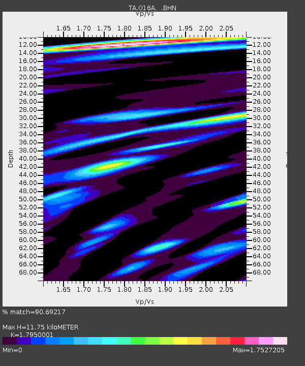
| Estimated Moho Depth: |
11.75 km |
| Estimated Crust Vp/Vs: |
1.80 |
| Assumed Crust Vp: |
6.155 km/s |
| Estimated Crust Vs: |
3.429 km/s |
| Estimated Crust Poisson's Ratio: |
0.27 |
|
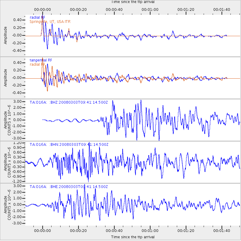
| Radial Match: |
90.69217 % |
| Radial Bump: |
400 |
| Transverse Match: |
89.95096 % |
| Transverse Bump: |
400 |
| SOD ConfigId: |
2564 |
| Insert Time: |
2010-03-06 00:21:05.702 +0000 |
| GWidth: |
2.5 |
| Max Bumps: |
400 |
| Tol: |
0.001 |
|
Signal To Noise
| Channel | StoN | STA | LTA |
| TA:O16A: :BHN:20080303T09:41:14.500Z | 1.8124458 | 1.624089E-7 | 8.960759E-8 |
| TA:O16A: :BHE:20080303T09:41:14.500Z | 1.0470965 | 1.5364691E-7 | 1.4673616E-7 |
| TA:O16A: :BHZ:20080303T09:41:14.500Z | 2.485529 | 3.3923277E-7 | 1.3648312E-7 |
| Arrivals |
| Ps | 1.6 SECOND |
| PpPs | 5.1 SECOND |
| PsPs/PpSs | 6.7 SECOND |


