You are here: Home > Network List > TA - USArray Transportable Network (new EarthScope stations) Stations List
> Station R33M Jennings River, BC, CAN > Earthquake Result Viewer
R33M Jennings River, BC, CAN - Earthquake Result Viewer
| Earthquake location: |
Near Islands, Aleutian Islands |
| Earthquake latitude/longitude: |
54.0/170.9 |
| Earthquake time(UTC): |
2017/06/02 (153) 22:24:47 GMT |
| Earthquake Depth: |
8.2 km |
| Earthquake Magnitude: |
6.8 Mww |
| Earthquake Catalog/Contributor: |
NEIC PDE/us |
|
| Network: |
TA USArray Transportable Network (new EarthScope stations) |
| Station: |
R33M Jennings River, BC, CAN |
| Lat/Lon: |
59.39 N/130.97 W |
| Elevation: |
1437 m |
|
| Distance: |
31.4 deg |
| Az: |
56.397 deg |
| Baz: |
286.189 deg |
| Ray Param: |
0.07906992 |
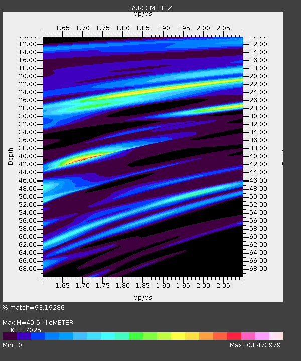
| Estimated Moho Depth: |
40.5 km |
| Estimated Crust Vp/Vs: |
1.70 |
| Assumed Crust Vp: |
6.597 km/s |
| Estimated Crust Vs: |
3.875 km/s |
| Estimated Crust Poisson's Ratio: |
0.24 |
|
| Radial Match: |
93.19286 % |
| Radial Bump: |
373 |
| Transverse Match: |
76.47447 % |
| Transverse Bump: |
400 |
| SOD ConfigId: |
13570011 |
| Insert Time: |
2019-04-28 03:16:06.671 +0000 |
| GWidth: |
2.5 |
| Max Bumps: |
400 |
| Tol: |
0.001 |
|

Signal To Noise
| Channel | StoN | STA | LTA |
| TA:R33M: :BHZ:20170602T22:30:38.974993Z | 25.72098 | 2.205194E-6 | 8.573522E-8 |
| TA:R33M: :BHN:20170602T22:30:38.974993Z | 13.096305 | 7.79873E-7 | 5.9549087E-8 |
| TA:R33M: :BHE:20170602T22:30:38.974993Z | 24.894157 | 1.2956633E-6 | 5.2046882E-8 |
| Arrivals |
| Ps | 4.7 SECOND |
| PpPs | 15 SECOND |
| PsPs/PpSs | 20 SECOND |


