You are here: Home > Network List > TA - USArray Transportable Network (new EarthScope stations) Stations List
> Station U35K Hyder, AK, USA > Earthquake Result Viewer
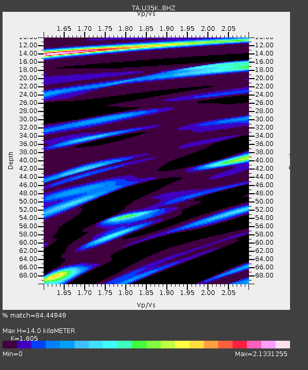
U35K Hyder, AK, USA - Earthquake Result Viewer
| Earthquake location: |
Near Islands, Aleutian Islands |
| Earthquake latitude/longitude: |
54.0/170.9 |
| Earthquake time(UTC): |
2017/06/02 (153) 22:24:47 GMT |
| Earthquake Depth: |
8.2 km |
| Earthquake Magnitude: |
6.8 Mww |
| Earthquake Catalog/Contributor: |
NEIC PDE/us |
|
| Network: |
TA USArray Transportable Network (new EarthScope stations) |
| Station: |
U35K Hyder, AK, USA |
| Lat/Lon: |
55.92 N/130.03 W |
| Elevation: |
17 m |
|
| Distance: |
33.1 deg |
| Az: |
62.267 deg |
| Baz: |
291.95 deg |
| Ray Param: |
0.078384094 |
| Estimated Moho Depth: |
14.0 km |
| Estimated Crust Vp/Vs: |
1.61 |
| Assumed Crust Vp: |
6.545 km/s |
| Estimated Crust Vs: |
4.078 km/s |
| Estimated Crust Poisson's Ratio: |
0.18 |
|
| Radial Match: |
84.44949 % |
| Radial Bump: |
400 |
| Transverse Match: |
60.227757 % |
| Transverse Bump: |
400 |
| SOD ConfigId: |
13570011 |
| Insert Time: |
2019-04-28 03:16:16.701 +0000 |
| GWidth: |
2.5 |
| Max Bumps: |
400 |
| Tol: |
0.001 |
|

Signal To Noise
| Channel | StoN | STA | LTA |
| TA:U35K: :BHZ:20170602T22:30:53.150011Z | 3.671905 | 2.192722E-6 | 5.9716194E-7 |
| TA:U35K: :BHN:20170602T22:30:53.150011Z | 1.344021 | 6.3139873E-7 | 4.697834E-7 |
| TA:U35K: :BHE:20170602T22:30:53.150011Z | 2.7306175 | 1.4800787E-6 | 5.4203076E-7 |
| Arrivals |
| Ps | 1.4 SECOND |
| PpPs | 5.1 SECOND |
| PsPs/PpSs | 6.5 SECOND |


