You are here: Home > Network List > UO - University of Oregon Regional Network Stations List
> Station RAIN Rainier, OR, USA > Earthquake Result Viewer
RAIN Rainier, OR, USA - Earthquake Result Viewer
| Earthquake location: |
Near Islands, Aleutian Islands |
| Earthquake latitude/longitude: |
54.0/170.9 |
| Earthquake time(UTC): |
2017/06/02 (153) 22:24:47 GMT |
| Earthquake Depth: |
8.2 km |
| Earthquake Magnitude: |
6.8 Mww |
| Earthquake Catalog/Contributor: |
NEIC PDE/us |
|
| Network: |
UO University of Oregon Regional Network |
| Station: |
RAIN Rainier, OR, USA |
| Lat/Lon: |
46.08 N/123.01 W |
| Elevation: |
236 m |
|
| Distance: |
41.7 deg |
| Az: |
72.901 deg |
| Baz: |
305.891 deg |
| Ray Param: |
0.07360982 |
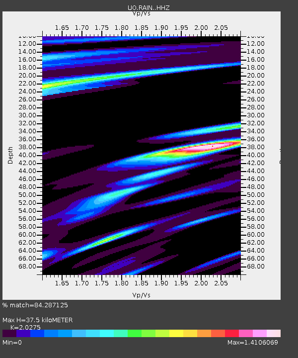
| Estimated Moho Depth: |
37.5 km |
| Estimated Crust Vp/Vs: |
2.03 |
| Assumed Crust Vp: |
6.566 km/s |
| Estimated Crust Vs: |
3.239 km/s |
| Estimated Crust Poisson's Ratio: |
0.34 |
|
| Radial Match: |
84.287125 % |
| Radial Bump: |
400 |
| Transverse Match: |
60.900486 % |
| Transverse Bump: |
400 |
| SOD ConfigId: |
13570011 |
| Insert Time: |
2019-04-28 03:16:58.827 +0000 |
| GWidth: |
2.5 |
| Max Bumps: |
400 |
| Tol: |
0.001 |
|

Signal To Noise
| Channel | StoN | STA | LTA |
| UO:RAIN: :HHZ:20170602T22:32:06.438005Z | 12.392243 | 3.0372494E-6 | 2.450928E-7 |
| UO:RAIN: :HHN:20170602T22:32:06.438005Z | 3.4326763 | 1.4247178E-6 | 4.1504578E-7 |
| UO:RAIN: :HHE:20170602T22:32:06.438005Z | 3.3172903 | 1.4719333E-6 | 4.4371555E-7 |
| Arrivals |
| Ps | 6.2 SECOND |
| PpPs | 16 SECOND |
| PsPs/PpSs | 22 SECOND |


