You are here: Home > Network List > UO - University of Oregon Regional Network Stations List
> Station WOOD Lake of the Woods, OR, USA > Earthquake Result Viewer
WOOD Lake of the Woods, OR, USA - Earthquake Result Viewer
| Earthquake location: |
Near Islands, Aleutian Islands |
| Earthquake latitude/longitude: |
54.0/170.9 |
| Earthquake time(UTC): |
2017/06/02 (153) 22:24:47 GMT |
| Earthquake Depth: |
8.2 km |
| Earthquake Magnitude: |
6.8 Mww |
| Earthquake Catalog/Contributor: |
NEIC PDE/us |
|
| Network: |
UO University of Oregon Regional Network |
| Station: |
WOOD Lake of the Woods, OR, USA |
| Lat/Lon: |
42.22 N/122.30 W |
| Elevation: |
1437 m |
|
| Distance: |
44.5 deg |
| Az: |
76.926 deg |
| Baz: |
309.321 deg |
| Ray Param: |
0.07188536 |
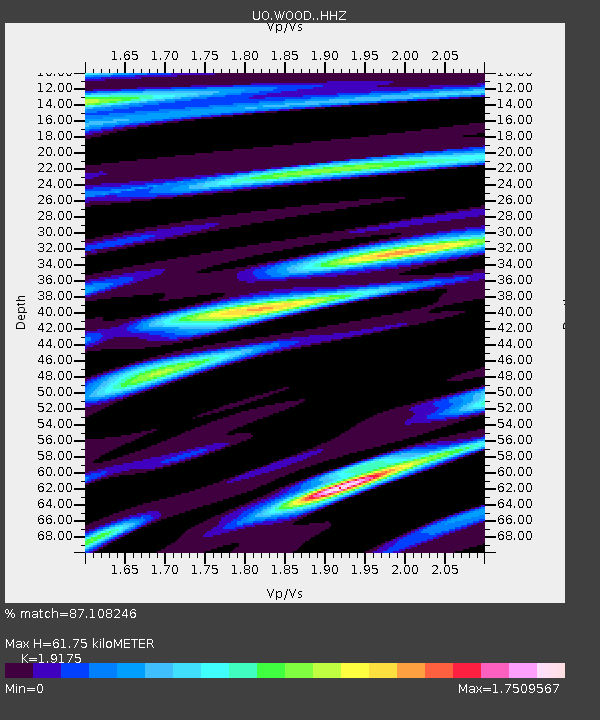
| Estimated Moho Depth: |
61.75 km |
| Estimated Crust Vp/Vs: |
1.92 |
| Assumed Crust Vp: |
6.522 km/s |
| Estimated Crust Vs: |
3.401 km/s |
| Estimated Crust Poisson's Ratio: |
0.31 |
|
| Radial Match: |
87.108246 % |
| Radial Bump: |
400 |
| Transverse Match: |
83.0889 % |
| Transverse Bump: |
400 |
| SOD ConfigId: |
13570011 |
| Insert Time: |
2019-04-28 03:17:02.875 +0000 |
| GWidth: |
2.5 |
| Max Bumps: |
400 |
| Tol: |
0.001 |
|

Signal To Noise
| Channel | StoN | STA | LTA |
| UO:WOOD: :HHZ:20170602T22:32:28.748003Z | 24.628658 | 3.5893331E-6 | 1.4573807E-7 |
| UO:WOOD: :HHN:20170602T22:32:28.748003Z | 7.7244806 | 1.2006254E-6 | 1.5543122E-7 |
| UO:WOOD: :HHE:20170602T22:32:28.748003Z | 7.911443 | 1.0965247E-6 | 1.3859983E-7 |
| Arrivals |
| Ps | 9.2 SECOND |
| PpPs | 26 SECOND |
| PsPs/PpSs | 35 SECOND |


