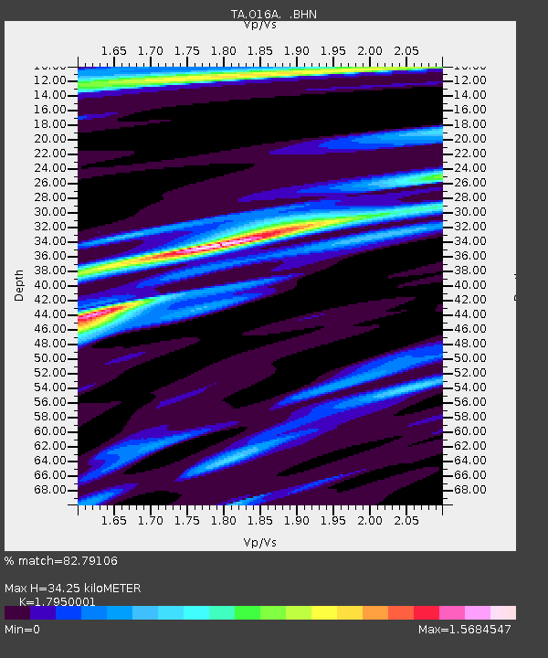
O16A Springville, UT, USA - Earthquake Result Viewer
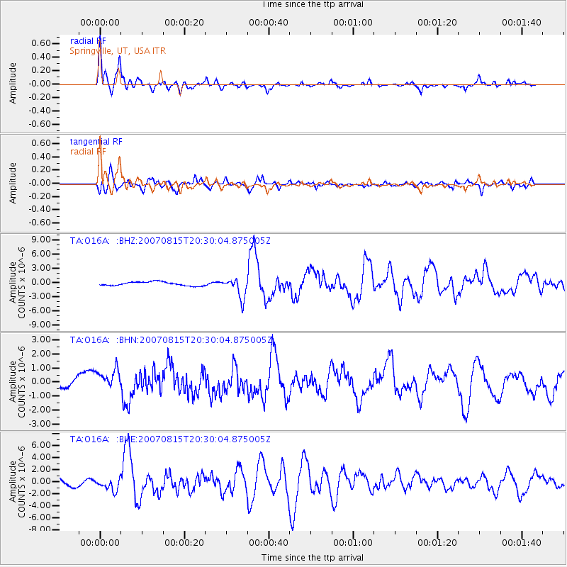
Earthquake location: Andreanof Islands, Aleutian Is.
Earthquake latitude/longitude: 50.3/-177.5
Earthquake time(UTC): 2007/08/15 (227) 20:22:11 GMT
Earthquake Depth: 9.0 km
Earthquake Magnitude: 6.3 MB, 6.2 MS, 6.4 MW, 5.9 ML
Earthquake Catalog/Contributor: WHDF/NEIC
Network: TA USArray Transportable Network (new EarthScope stations)
Station: O16A Springville, UT, USA
Lat/Lon: 40.21 N/111.50 W
Elevation: 1789 m
Distance: 46.1 deg
Az: 76.076 deg
Baz: 305.67 deg
Ray Param: 0.07082919
Estimated Moho Depth: 34.25 km
Estimated Crust Vp/Vs: 1.80
Assumed Crust Vp: 6.155 km/s
Estimated Crust Vs: 3.429 km/s
Estimated Crust Poisson's Ratio: 0.27
Radial Match: 82.79106 %
Radial Bump: 385
Transverse Match: 75.115135 %
Transverse Bump: 400
SOD ConfigId: 2564
Insert Time: 2010-03-06 00:21:34.951 +0000
GWidth: 2.5
Max Bumps: 400
Tol: 0.001

Signal To Noise

ChannelStoNSTALTA
TA:O16A: :BHN:20070815T20:30:04.875005Z3.34520348.2037565E-72.452394E-7
TA:O16A: :BHE:20070815T20:30:04.875005Z1.26673569.4840686E-77.4870155E-7
TA:O16A: :BHZ:20070815T20:30:04.875005Z5.39192772.1672563E-64.0194462E-7
Arrivals
Ps4.7 SECOND
PpPs15 SECOND
PsPs/PpSs19 SECOND