You are here: Home > Network List > UW - Pacific Northwest Regional Seismic Network Stations List
> Station MRBL Marblemount, WA, USA > Earthquake Result Viewer
MRBL Marblemount, WA, USA - Earthquake Result Viewer
| Earthquake location: |
Near Islands, Aleutian Islands |
| Earthquake latitude/longitude: |
54.0/170.9 |
| Earthquake time(UTC): |
2017/06/02 (153) 22:24:47 GMT |
| Earthquake Depth: |
8.2 km |
| Earthquake Magnitude: |
6.8 Mww |
| Earthquake Catalog/Contributor: |
NEIC PDE/us |
|
| Network: |
UW Pacific Northwest Regional Seismic Network |
| Station: |
MRBL Marblemount, WA, USA |
| Lat/Lon: |
48.52 N/121.48 W |
| Elevation: |
75 m |
|
| Distance: |
41.2 deg |
| Az: |
68.986 deg |
| Baz: |
304.075 deg |
| Ray Param: |
0.07395421 |
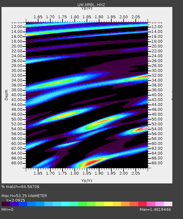
| Estimated Moho Depth: |
53.25 km |
| Estimated Crust Vp/Vs: |
2.09 |
| Assumed Crust Vp: |
6.566 km/s |
| Estimated Crust Vs: |
3.138 km/s |
| Estimated Crust Poisson's Ratio: |
0.35 |
|
| Radial Match: |
84.56706 % |
| Radial Bump: |
400 |
| Transverse Match: |
85.81419 % |
| Transverse Bump: |
400 |
| SOD ConfigId: |
13570011 |
| Insert Time: |
2019-04-28 03:17:29.157 +0000 |
| GWidth: |
2.5 |
| Max Bumps: |
400 |
| Tol: |
0.001 |
|
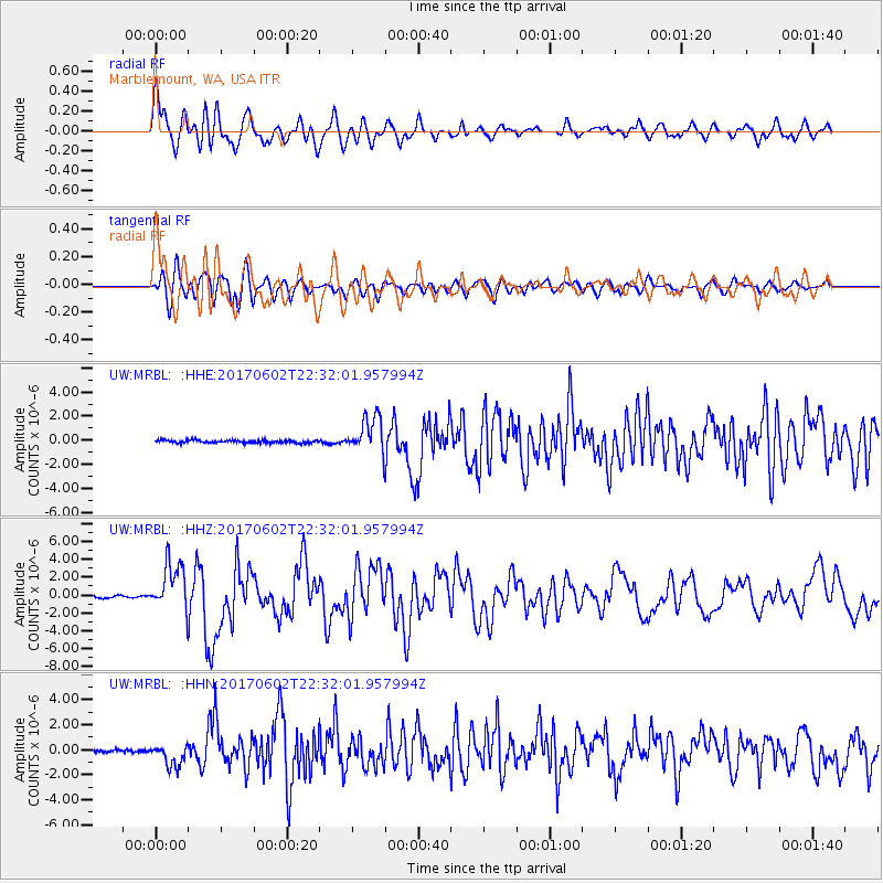
Signal To Noise
| Channel | StoN | STA | LTA |
| UW:MRBL: :HHZ:20170602T22:32:01.957994Z | 29.890049 | 2.6571022E-6 | 8.889588E-8 |
| UW:MRBL: :HHN:20170602T22:32:01.957994Z | 8.293626 | 9.027991E-7 | 1.0885458E-7 |
| UW:MRBL: :HHE:20170602T22:32:01.957994Z | 12.701117 | 1.4881845E-6 | 1.1716958E-7 |
| Arrivals |
| Ps | 9.4 SECOND |
| PpPs | 24 SECOND |
| PsPs/PpSs | 33 SECOND |


