You are here: Home > Network List > X416 - Monitoring Active Faults for Tectonic Mapping Efforts in Washington State Stations List
> Station MA06 Snohomish County, WA, USA > Earthquake Result Viewer
MA06 Snohomish County, WA, USA - Earthquake Result Viewer
| Earthquake location: |
Near Islands, Aleutian Islands |
| Earthquake latitude/longitude: |
54.0/170.9 |
| Earthquake time(UTC): |
2017/06/02 (153) 22:24:47 GMT |
| Earthquake Depth: |
8.2 km |
| Earthquake Magnitude: |
6.8 Mww |
| Earthquake Catalog/Contributor: |
NEIC PDE/us |
|
| Network: |
X4 Monitoring Active Faults for Tectonic Mapping Efforts in Washington State |
| Station: |
MA06 Snohomish County, WA, USA |
| Lat/Lon: |
47.91 N/121.80 W |
| Elevation: |
-1.0 m |
|
| Distance: |
41.4 deg |
| Az: |
69.927 deg |
| Baz: |
304.551 deg |
| Ray Param: |
0.07384606 |
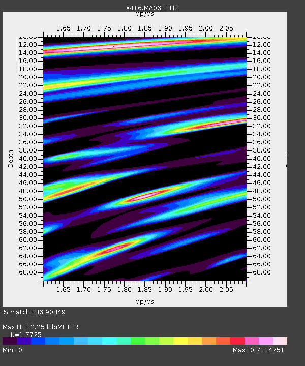
| Estimated Moho Depth: |
12.25 km |
| Estimated Crust Vp/Vs: |
1.77 |
| Assumed Crust Vp: |
6.597 km/s |
| Estimated Crust Vs: |
3.722 km/s |
| Estimated Crust Poisson's Ratio: |
0.27 |
|
| Radial Match: |
86.90849 % |
| Radial Bump: |
345 |
| Transverse Match: |
83.33024 % |
| Transverse Bump: |
400 |
| SOD ConfigId: |
13570011 |
| Insert Time: |
2019-04-28 03:18:01.190 +0000 |
| GWidth: |
2.5 |
| Max Bumps: |
400 |
| Tol: |
0.001 |
|

Signal To Noise
| Channel | StoN | STA | LTA |
| X4:MA06: :HHZ:20170602T22:32:03.374987Z | 43.36284 | 3.1821114E-6 | 7.3383376E-8 |
| X4:MA06: :HHN:20170602T22:32:03.374987Z | 6.008231 | 5.7461295E-7 | 9.563762E-8 |
| X4:MA06: :HHE:20170602T22:32:03.374987Z | 16.36766 | 1.7586339E-6 | 1.0744566E-7 |
| Arrivals |
| Ps | 1.5 SECOND |
| PpPs | 4.8 SECOND |
| PsPs/PpSs | 6.3 SECOND |


