You are here: Home > Network List > TA - USArray Transportable Network (new EarthScope stations) Stations List
> Station O16A Springville, UT, USA > Earthquake Result Viewer
O16A Springville, UT, USA - Earthquake Result Viewer
| Earthquake location: |
South Of Panama |
| Earthquake latitude/longitude: |
5.7/-82.8 |
| Earthquake time(UTC): |
2009/03/12 (071) 23:23:34 GMT |
| Earthquake Depth: |
9.0 km |
| Earthquake Magnitude: |
6.1 MB, 5.9 MS, 6.3 MW, 6.2 MW |
| Earthquake Catalog/Contributor: |
WHDF/NEIC |
|
| Network: |
TA USArray Transportable Network (new EarthScope stations) |
| Station: |
O16A Springville, UT, USA |
| Lat/Lon: |
40.21 N/111.50 W |
| Elevation: |
1789 m |
|
| Distance: |
43.0 deg |
| Az: |
327.313 deg |
| Baz: |
135.433 deg |
| Ray Param: |
0.07284609 |
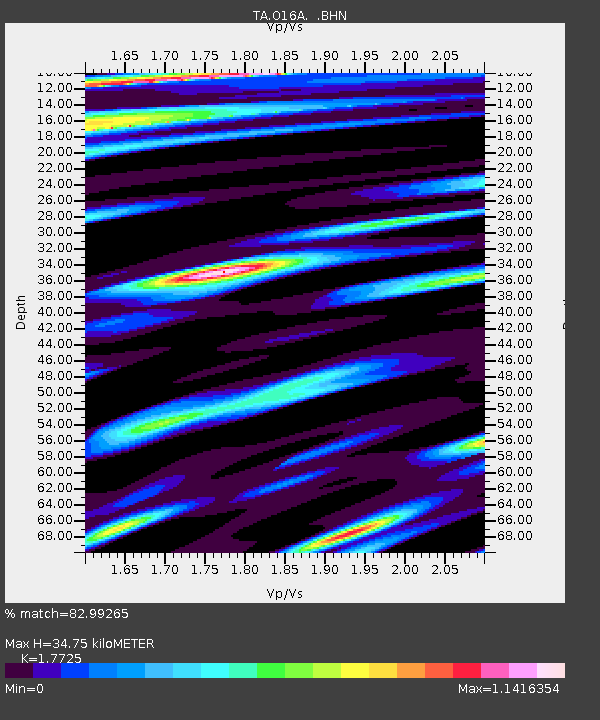
| Estimated Moho Depth: |
34.75 km |
| Estimated Crust Vp/Vs: |
1.77 |
| Assumed Crust Vp: |
6.155 km/s |
| Estimated Crust Vs: |
3.472 km/s |
| Estimated Crust Poisson's Ratio: |
0.27 |
|
| Radial Match: |
82.99265 % |
| Radial Bump: |
400 |
| Transverse Match: |
72.44764 % |
| Transverse Bump: |
400 |
| SOD ConfigId: |
2658 |
| Insert Time: |
2010-03-06 00:22:01.839 +0000 |
| GWidth: |
2.5 |
| Max Bumps: |
400 |
| Tol: |
0.001 |
|
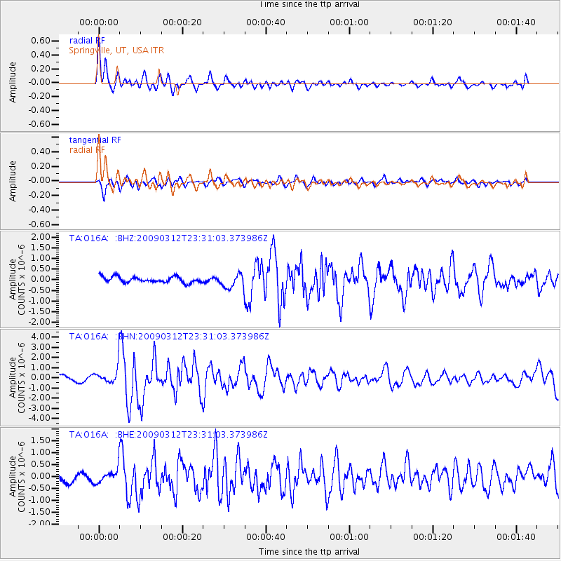
Signal To Noise
| Channel | StoN | STA | LTA |
| TA:O16A: :BHN:20090312T23:31:03.373986Z | 3.3677444 | 8.3199285E-7 | 2.470475E-7 |
| TA:O16A: :BHE:20090312T23:31:03.373986Z | 2.2887444 | 3.0363157E-7 | 1.3266293E-7 |
| TA:O16A: :BHZ:20090312T23:31:03.373986Z | 2.5648017 | 3.4403826E-7 | 1.3413836E-7 |
| Arrivals |
| Ps | 4.6 SECOND |
| PpPs | 15 SECOND |
| PsPs/PpSs | 19 SECOND |


