You are here: Home > Network List > YR16 - Armatrice Sequence International Stations List
> Station ED12 CORTIGNO > Earthquake Result Viewer
ED12 CORTIGNO - Earthquake Result Viewer
| Earthquake location: |
Near Islands, Aleutian Islands |
| Earthquake latitude/longitude: |
54.0/170.9 |
| Earthquake time(UTC): |
2017/06/02 (153) 22:24:47 GMT |
| Earthquake Depth: |
8.2 km |
| Earthquake Magnitude: |
6.8 Mww |
| Earthquake Catalog/Contributor: |
NEIC PDE/us |
|
| Network: |
YR Armatrice Sequence International |
| Station: |
ED12 CORTIGNO |
| Lat/Lon: |
42.81 N/12.98 E |
| Elevation: |
1127 m |
|
| Distance: |
81.7 deg |
| Az: |
343.775 deg |
| Baz: |
12.944 deg |
| Ray Param: |
0.04740452 |
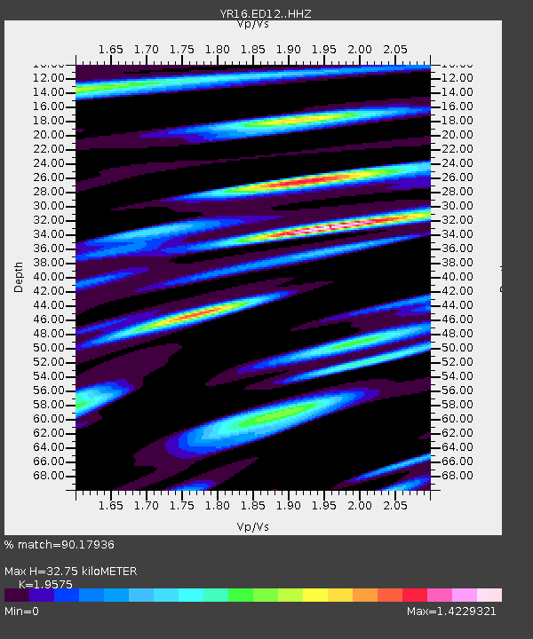
| Estimated Moho Depth: |
32.75 km |
| Estimated Crust Vp/Vs: |
1.96 |
| Assumed Crust Vp: |
6.276 km/s |
| Estimated Crust Vs: |
3.206 km/s |
| Estimated Crust Poisson's Ratio: |
0.32 |
|
| Radial Match: |
90.17936 % |
| Radial Bump: |
400 |
| Transverse Match: |
84.36511 % |
| Transverse Bump: |
400 |
| SOD ConfigId: |
13570011 |
| Insert Time: |
2019-04-28 03:18:40.190 +0000 |
| GWidth: |
2.5 |
| Max Bumps: |
400 |
| Tol: |
0.001 |
|

Signal To Noise
| Channel | StoN | STA | LTA |
| YR:ED12: :HHZ:20170602T22:36:35.289995Z | 5.579452 | 5.8614404E-7 | 1.05054056E-7 |
| YR:ED12: :HHN:20170602T22:36:35.289995Z | 4.1727223 | 4.957021E-7 | 1.1879585E-7 |
| YR:ED12: :HHE:20170602T22:36:35.289995Z | 2.584934 | 2.0803355E-7 | 8.047925E-8 |
| Arrivals |
| Ps | 5.1 SECOND |
| PpPs | 15 SECOND |
| PsPs/PpSs | 20 SECOND |


