You are here: Home > Network List > IW - Intermountain West Stations List
> Station MOOW Moose Ponds, Wyoming, USA > Earthquake Result Viewer
MOOW Moose Ponds, Wyoming, USA - Earthquake Result Viewer
*The percent match for this event was below the threshold and hence no stack was calculated.
| Earthquake location: |
North Of Ascension Island |
| Earthquake latitude/longitude: |
-1.4/-15.8 |
| Earthquake time(UTC): |
2015/12/18 (352) 11:46:48 GMT |
| Earthquake Depth: |
10 km |
| Earthquake Magnitude: |
5.6 MB |
| Earthquake Catalog/Contributor: |
NEIC PDE/NEIC COMCAT |
|
| Network: |
IW Intermountain West |
| Station: |
MOOW Moose Ponds, Wyoming, USA |
| Lat/Lon: |
43.75 N/110.74 W |
| Elevation: |
2128 m |
|
| Distance: |
94.5 deg |
| Az: |
313.593 deg |
| Baz: |
87.585 deg |
| Ray Param: |
$rayparam |
*The percent match for this event was below the threshold and hence was not used in the summary stack. |
|
| Radial Match: |
76.9883 % |
| Radial Bump: |
400 |
| Transverse Match: |
84.78235 % |
| Transverse Bump: |
400 |
| SOD ConfigId: |
1259291 |
| Insert Time: |
2016-01-01 12:15:50.702 +0000 |
| GWidth: |
2.5 |
| Max Bumps: |
400 |
| Tol: |
0.001 |
|
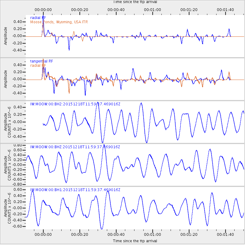
Signal To Noise
| Channel | StoN | STA | LTA |
| IW:MOOW:00:BHZ:20151218T11:59:37.469016Z | 0.6485823 | 2.2125136E-7 | 3.4113071E-7 |
| IW:MOOW:00:BH1:20151218T11:59:37.469016Z | 0.50204736 | 1.3928445E-7 | 2.774329E-7 |
| IW:MOOW:00:BH2:20151218T11:59:37.469016Z | 2.540592 | 3.843736E-7 | 1.5129294E-7 |
| Arrivals |
| Ps | |
| PpPs | |
| PsPs/PpSs | |


