You are here: Home > Network List > TA - USArray Transportable Network (new EarthScope stations) Stations List
> Station O16A Springville, UT, USA > Earthquake Result Viewer
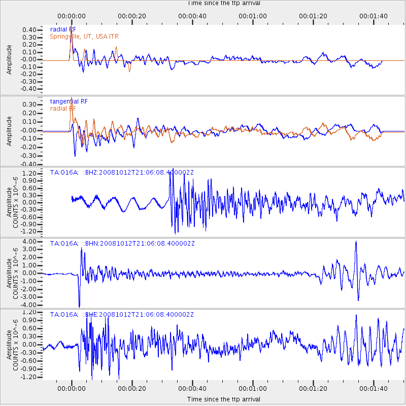
O16A Springville, UT, USA - Earthquake Result Viewer
*The percent match for this event was below the threshold and hence no stack was calculated.
| Earthquake location: |
Southern Bolivia |
| Earthquake latitude/longitude: |
-20.1/-65.0 |
| Earthquake time(UTC): |
2008/10/12 (286) 20:55:41 GMT |
| Earthquake Depth: |
353 km |
| Earthquake Magnitude: |
6.0 MB, 6.2 MW, 6.2 MW |
| Earthquake Catalog/Contributor: |
WHDF/NEIC |
|
| Network: |
TA USArray Transportable Network (new EarthScope stations) |
| Station: |
O16A Springville, UT, USA |
| Lat/Lon: |
40.21 N/111.50 W |
| Elevation: |
1789 m |
|
| Distance: |
74.0 deg |
| Az: |
324.68 deg |
| Baz: |
134.816 deg |
| Ray Param: |
$rayparam |
*The percent match for this event was below the threshold and hence was not used in the summary stack. |
|
| Radial Match: |
76.40941 % |
| Radial Bump: |
400 |
| Transverse Match: |
59.161995 % |
| Transverse Bump: |
400 |
| SOD ConfigId: |
2556 |
| Insert Time: |
2010-03-06 00:22:50.765 +0000 |
| GWidth: |
2.5 |
| Max Bumps: |
400 |
| Tol: |
0.001 |
|
Signal To Noise
| Channel | StoN | STA | LTA |
| TA:O16A: :BHN:20081012T21:06:08.400002Z | 13.768141 | 1.4113224E-6 | 1.0250639E-7 |
| TA:O16A: :BHE:20081012T21:06:08.400002Z | 3.2791324 | 3.281277E-7 | 1.000654E-7 |
| TA:O16A: :BHZ:20081012T21:06:08.400002Z | 2.9654613 | 5.287203E-7 | 1.7829277E-7 |
| Arrivals |
| Ps | |
| PpPs | |
| PsPs/PpSs | |


