You are here: Home > Network List > TA - USArray Transportable Network (new EarthScope stations) Stations List
> Station F26K Sheenjek River, AK, USA > Earthquake Result Viewer
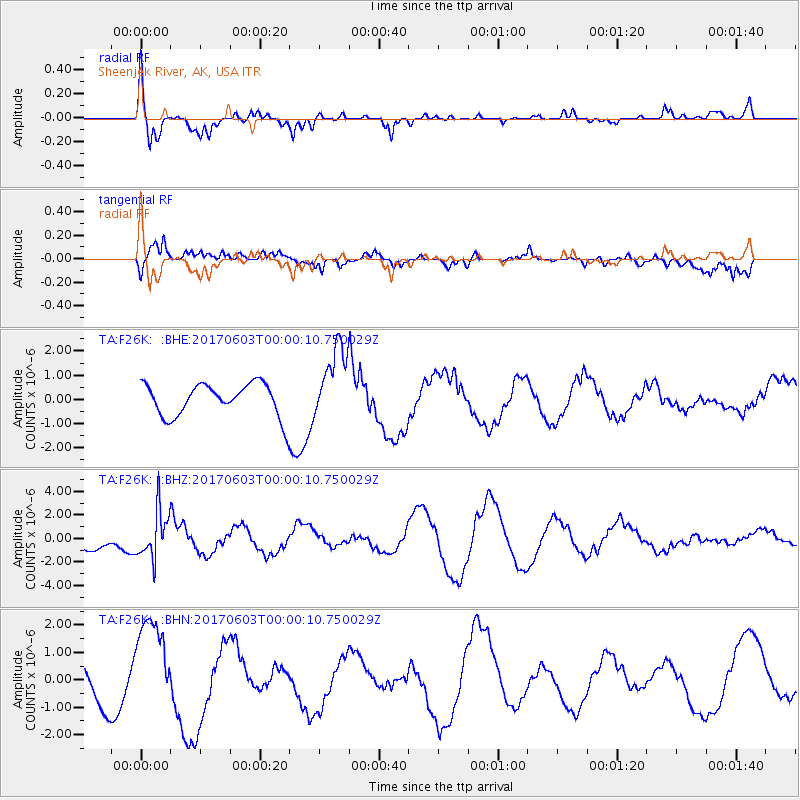
F26K Sheenjek River, AK, USA - Earthquake Result Viewer
*The percent match for this event was below the threshold and hence no stack was calculated.
| Earthquake location: |
Near N Coast Of New Guinea, P.N.G. |
| Earthquake latitude/longitude: |
-4.7/145.1 |
| Earthquake time(UTC): |
2017/06/02 (153) 23:48:17 GMT |
| Earthquake Depth: |
194 km |
| Earthquake Magnitude: |
5.9 Mww |
| Earthquake Catalog/Contributor: |
NEIC PDE/us |
|
| Network: |
TA USArray Transportable Network (new EarthScope stations) |
| Station: |
F26K Sheenjek River, AK, USA |
| Lat/Lon: |
67.69 N/144.15 W |
| Elevation: |
683 m |
|
| Distance: |
87.1 deg |
| Az: |
21.147 deg |
| Baz: |
250.37 deg |
| Ray Param: |
$rayparam |
*The percent match for this event was below the threshold and hence was not used in the summary stack. |
|
| Radial Match: |
69.84639 % |
| Radial Bump: |
356 |
| Transverse Match: |
64.808525 % |
| Transverse Bump: |
400 |
| SOD ConfigId: |
13570011 |
| Insert Time: |
2019-04-28 03:21:33.250 +0000 |
| GWidth: |
2.5 |
| Max Bumps: |
400 |
| Tol: |
0.001 |
|
Signal To Noise
| Channel | StoN | STA | LTA |
| TA:F26K: :BHZ:20170603T00:00:10.750029Z | 1.4422987 | 2.030939E-6 | 1.4081265E-6 |
| TA:F26K: :BHN:20170603T00:00:10.750029Z | 3.562864 | 1.8400193E-6 | 5.164439E-7 |
| TA:F26K: :BHE:20170603T00:00:10.750029Z | 2.3056552 | 1.5426557E-6 | 6.690747E-7 |
| Arrivals |
| Ps | |
| PpPs | |
| PsPs/PpSs | |


