You are here: Home > Network List > TA - USArray Transportable Network (new EarthScope stations) Stations List
> Station O16A Springville, UT, USA > Earthquake Result Viewer
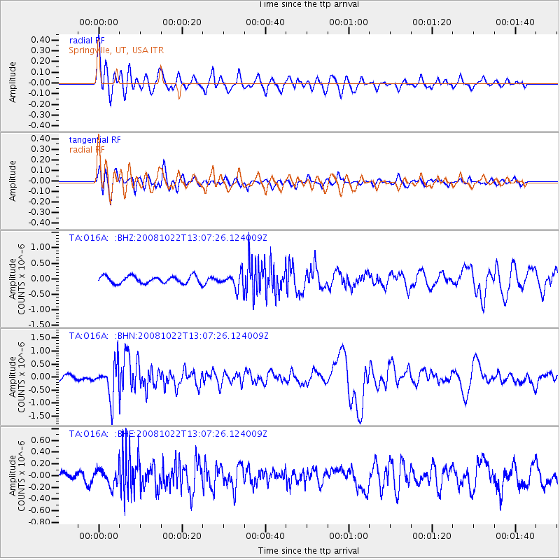
O16A Springville, UT, USA - Earthquake Result Viewer
*The percent match for this event was below the threshold and hence no stack was calculated.
| Earthquake location: |
Tonga Islands |
| Earthquake latitude/longitude: |
-18.4/-175.4 |
| Earthquake time(UTC): |
2008/10/22 (296) 12:55:57 GMT |
| Earthquake Depth: |
233 km |
| Earthquake Magnitude: |
5.9 MB, 6.4 MW, 6.3 MW |
| Earthquake Catalog/Contributor: |
WHDF/NEIC |
|
| Network: |
TA USArray Transportable Network (new EarthScope stations) |
| Station: |
O16A Springville, UT, USA |
| Lat/Lon: |
40.21 N/111.50 W |
| Elevation: |
1789 m |
|
| Distance: |
83.2 deg |
| Az: |
43.816 deg |
| Baz: |
239.126 deg |
| Ray Param: |
$rayparam |
*The percent match for this event was below the threshold and hence was not used in the summary stack. |
|
| Radial Match: |
74.61704 % |
| Radial Bump: |
400 |
| Transverse Match: |
64.07828 % |
| Transverse Bump: |
400 |
| SOD ConfigId: |
2556 |
| Insert Time: |
2010-03-06 00:22:53.847 +0000 |
| GWidth: |
2.5 |
| Max Bumps: |
400 |
| Tol: |
0.001 |
|
Signal To Noise
| Channel | StoN | STA | LTA |
| TA:O16A: :BHN:20081022T13:07:26.124009Z | 2.221771 | 6.6324316E-7 | 2.9852004E-7 |
| TA:O16A: :BHE:20081022T13:07:26.124009Z | 1.1097909 | 1.4980486E-7 | 1.3498476E-7 |
| TA:O16A: :BHZ:20081022T13:07:26.124009Z | 2.2181385 | 2.5712512E-7 | 1.1591932E-7 |
| Arrivals |
| Ps | |
| PpPs | |
| PsPs/PpSs | |


