You are here: Home > Network List > TA - USArray Transportable Network (new EarthScope stations) Stations List
> Station O16A Springville, UT, USA > Earthquake Result Viewer
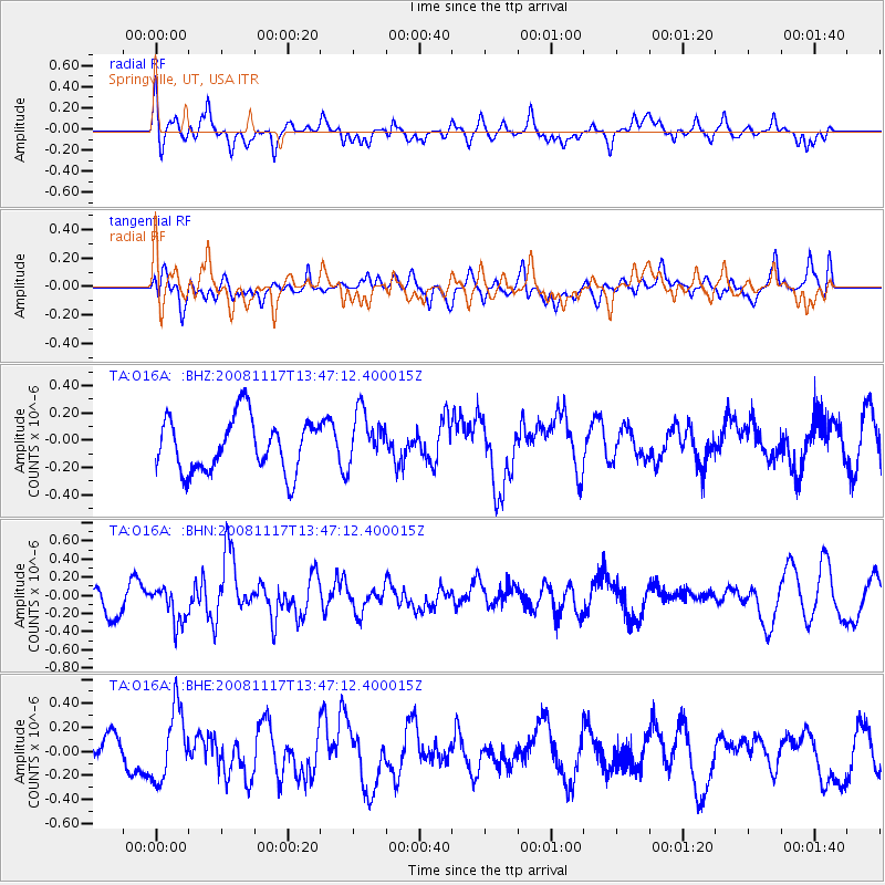
O16A Springville, UT, USA - Earthquake Result Viewer
*The percent match for this event was below the threshold and hence no stack was calculated.
| Earthquake location: |
Arctic Ocean |
| Earthquake latitude/longitude: |
79.7/-115.7 |
| Earthquake time(UTC): |
2008/11/17 (322) 13:40:11 GMT |
| Earthquake Depth: |
10 km |
| Earthquake Magnitude: |
5.7 ML, 5.1 MB |
| Earthquake Catalog/Contributor: |
WHDF/NEIC |
|
| Network: |
TA USArray Transportable Network (new EarthScope stations) |
| Station: |
O16A Springville, UT, USA |
| Lat/Lon: |
40.21 N/111.50 W |
| Elevation: |
1789 m |
|
| Distance: |
39.6 deg |
| Az: |
175.016 deg |
| Baz: |
358.828 deg |
| Ray Param: |
$rayparam |
*The percent match for this event was below the threshold and hence was not used in the summary stack. |
|
| Radial Match: |
64.2587 % |
| Radial Bump: |
400 |
| Transverse Match: |
45.06957 % |
| Transverse Bump: |
400 |
| SOD ConfigId: |
2658 |
| Insert Time: |
2010-03-06 00:22:57.569 +0000 |
| GWidth: |
2.5 |
| Max Bumps: |
400 |
| Tol: |
0.001 |
|
Signal To Noise
| Channel | StoN | STA | LTA |
| TA:O16A: :BHN:20081117T13:47:12.400015Z | 1.1317974 | 2.0333611E-7 | 1.796577E-7 |
| TA:O16A: :BHE:20081117T13:47:12.400015Z | 1.9356488 | 2.9775356E-7 | 1.5382624E-7 |
| TA:O16A: :BHZ:20081117T13:47:12.400015Z | 1.0053829 | 1.9544552E-7 | 1.9439909E-7 |
| Arrivals |
| Ps | |
| PpPs | |
| PsPs/PpSs | |


