You are here: Home > Network List > TA - USArray Transportable Network (new EarthScope stations) Stations List
> Station O16A Springville, UT, USA > Earthquake Result Viewer
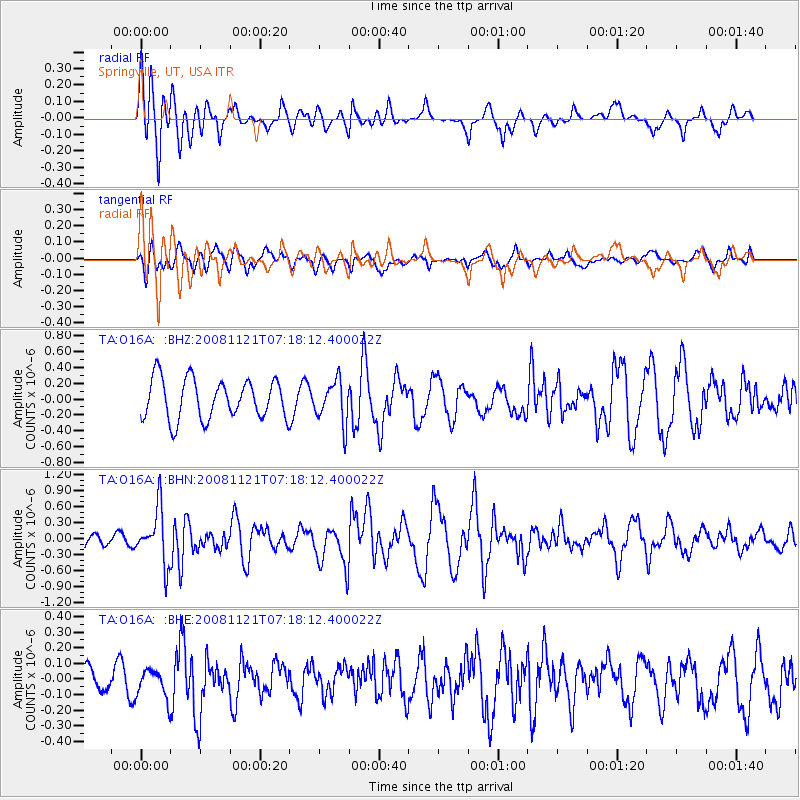
O16A Springville, UT, USA - Earthquake Result Viewer
*The percent match for this event was below the threshold and hence no stack was calculated.
| Earthquake location: |
Solomon Islands |
| Earthquake latitude/longitude: |
-8.9/159.6 |
| Earthquake time(UTC): |
2008/11/21 (326) 07:05:34 GMT |
| Earthquake Depth: |
118 km |
| Earthquake Magnitude: |
6.0 MB, 6.1 MW, 6.0 MW |
| Earthquake Catalog/Contributor: |
WHDF/NEIC |
|
| Network: |
TA USArray Transportable Network (new EarthScope stations) |
| Station: |
O16A Springville, UT, USA |
| Lat/Lon: |
40.21 N/111.50 W |
| Elevation: |
1789 m |
|
| Distance: |
94.9 deg |
| Az: |
50.222 deg |
| Baz: |
262.501 deg |
| Ray Param: |
$rayparam |
*The percent match for this event was below the threshold and hence was not used in the summary stack. |
|
| Radial Match: |
66.815056 % |
| Radial Bump: |
400 |
| Transverse Match: |
59.51343 % |
| Transverse Bump: |
400 |
| SOD ConfigId: |
2658 |
| Insert Time: |
2010-03-06 00:23:00.860 +0000 |
| GWidth: |
2.5 |
| Max Bumps: |
400 |
| Tol: |
0.001 |
|
Signal To Noise
| Channel | StoN | STA | LTA |
| TA:O16A: :BHN:20081121T07:18:12.400022Z | 2.5591333 | 5.0969413E-7 | 1.991667E-7 |
| TA:O16A: :BHE:20081121T07:18:12.400022Z | 0.8505612 | 9.01114E-8 | 1.05943464E-7 |
| TA:O16A: :BHZ:20081121T07:18:12.400022Z | 1.0624695 | 2.6723816E-7 | 2.515255E-7 |
| Arrivals |
| Ps | |
| PpPs | |
| PsPs/PpSs | |


