You are here: Home > Network List > TA - USArray Transportable Network (new EarthScope stations) Stations List
> Station O16A Springville, UT, USA > Earthquake Result Viewer
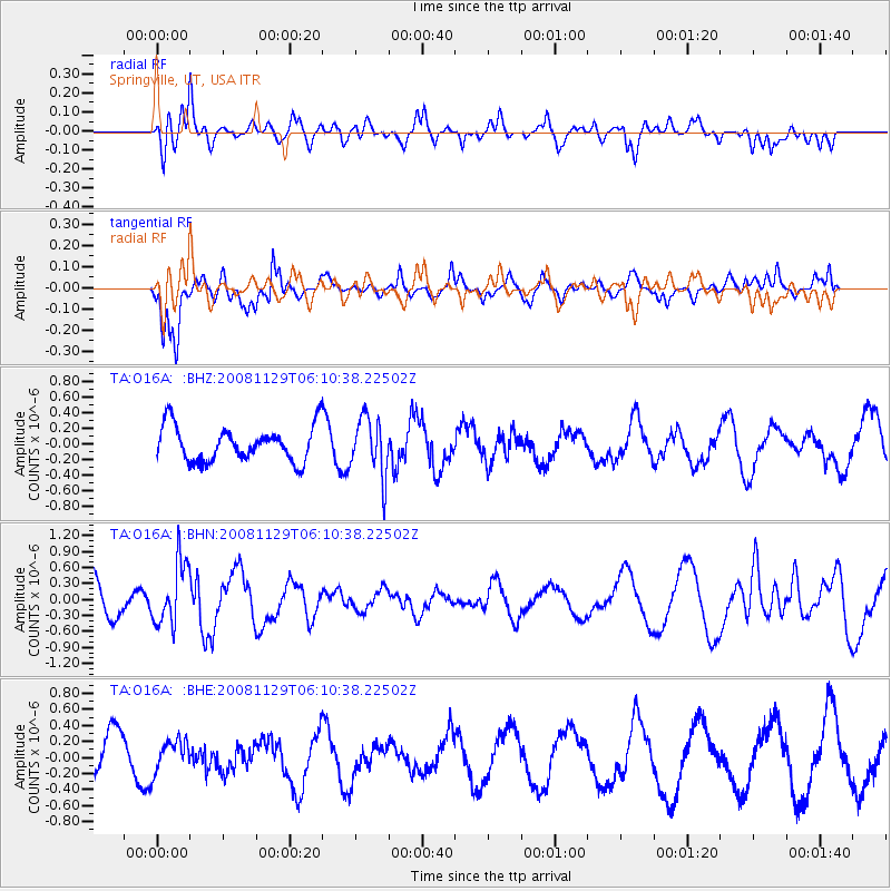
O16A Springville, UT, USA - Earthquake Result Viewer
*The percent match for this event was below the threshold and hence no stack was calculated.
| Earthquake location: |
Fiji Islands Region |
| Earthquake latitude/longitude: |
-18.7/-177.7 |
| Earthquake time(UTC): |
2008/11/29 (334) 05:59:16 GMT |
| Earthquake Depth: |
386 km |
| Earthquake Magnitude: |
5.7 MB, 6.0 MW, 5.9 MW |
| Earthquake Catalog/Contributor: |
WHDF/NEIC |
|
| Network: |
TA USArray Transportable Network (new EarthScope stations) |
| Station: |
O16A Springville, UT, USA |
| Lat/Lon: |
40.21 N/111.50 W |
| Elevation: |
1789 m |
|
| Distance: |
85.0 deg |
| Az: |
44.71 deg |
| Baz: |
240.541 deg |
| Ray Param: |
$rayparam |
*The percent match for this event was below the threshold and hence was not used in the summary stack. |
|
| Radial Match: |
71.41823 % |
| Radial Bump: |
400 |
| Transverse Match: |
79.87535 % |
| Transverse Bump: |
400 |
| SOD ConfigId: |
2658 |
| Insert Time: |
2010-03-06 00:23:02.460 +0000 |
| GWidth: |
2.5 |
| Max Bumps: |
400 |
| Tol: |
0.001 |
|
Signal To Noise
| Channel | StoN | STA | LTA |
| TA:O16A: :BHN:20081129T06:10:38.22502Z | 1.7345793 | 5.8586966E-7 | 3.3775896E-7 |
| TA:O16A: :BHE:20081129T06:10:38.22502Z | 0.9623966 | 1.9524758E-7 | 2.0287642E-7 |
| TA:O16A: :BHZ:20081129T06:10:38.22502Z | 1.6538246 | 3.685699E-7 | 2.2285913E-7 |
| Arrivals |
| Ps | |
| PpPs | |
| PsPs/PpSs | |


