You are here: Home > Network List > US - United States National Seismic Network Stations List
> Station WMOK Wichita Mountains, Oklahoma, USA > Earthquake Result Viewer
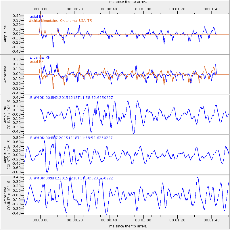
WMOK Wichita Mountains, Oklahoma, USA - Earthquake Result Viewer
*The percent match for this event was below the threshold and hence no stack was calculated.
| Earthquake location: |
North Of Ascension Island |
| Earthquake latitude/longitude: |
-1.4/-15.8 |
| Earthquake time(UTC): |
2015/12/18 (352) 11:46:48 GMT |
| Earthquake Depth: |
10 km |
| Earthquake Magnitude: |
5.6 MB |
| Earthquake Catalog/Contributor: |
NEIC PDE/NEIC COMCAT |
|
| Network: |
US United States National Seismic Network |
| Station: |
WMOK Wichita Mountains, Oklahoma, USA |
| Lat/Lon: |
34.74 N/98.78 W |
| Elevation: |
486 m |
|
| Distance: |
85.0 deg |
| Az: |
304.866 deg |
| Baz: |
95.121 deg |
| Ray Param: |
$rayparam |
*The percent match for this event was below the threshold and hence was not used in the summary stack. |
|
| Radial Match: |
64.43837 % |
| Radial Bump: |
353 |
| Transverse Match: |
59.628418 % |
| Transverse Bump: |
400 |
| SOD ConfigId: |
1259291 |
| Insert Time: |
2016-01-01 12:19:10.579 +0000 |
| GWidth: |
2.5 |
| Max Bumps: |
400 |
| Tol: |
0.001 |
|
Signal To Noise
| Channel | StoN | STA | LTA |
| US:WMOK:00:BHZ:20151218T11:58:52.625022Z | 2.2870119 | 4.6221967E-7 | 2.0210638E-7 |
| US:WMOK:00:BH1:20151218T11:58:52.625022Z | 0.72559476 | 1.6562699E-7 | 2.2826376E-7 |
| US:WMOK:00:BH2:20151218T11:58:52.625022Z | 1.8095458 | 2.1494917E-7 | 1.1878626E-7 |
| Arrivals |
| Ps | |
| PpPs | |
| PsPs/PpSs | |


