You are here: Home > Network List > TA - USArray Transportable Network (new EarthScope stations) Stations List
> Station O16A Springville, UT, USA > Earthquake Result Viewer
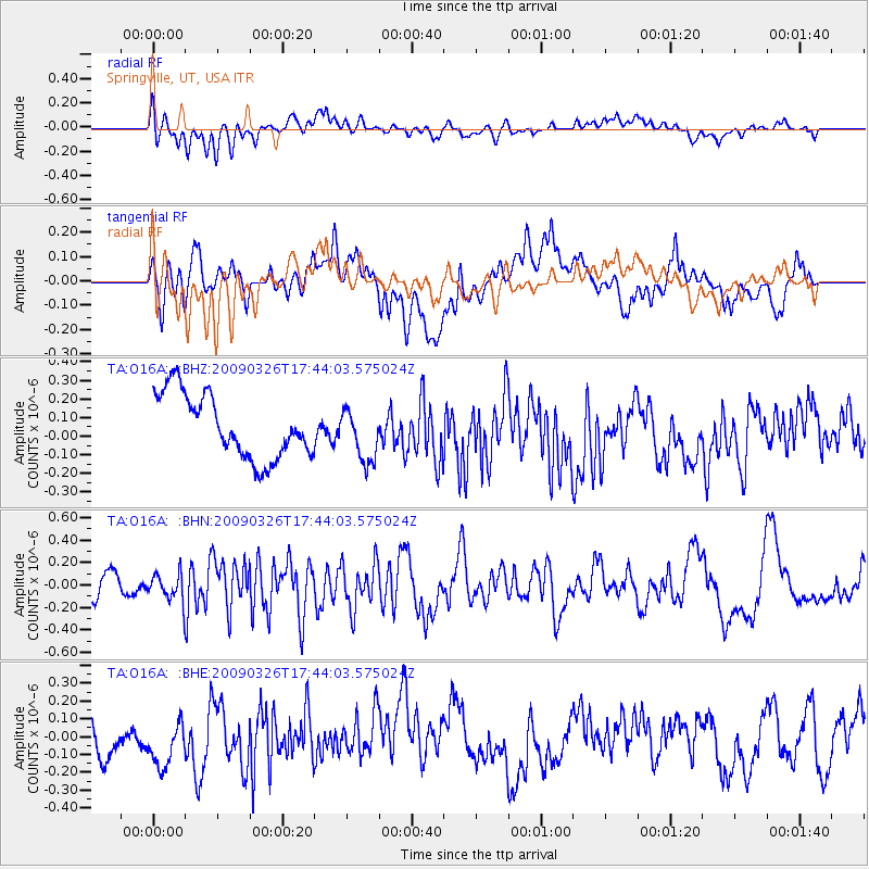
O16A Springville, UT, USA - Earthquake Result Viewer
*The percent match for this event was below the threshold and hence no stack was calculated.
| Earthquake location: |
Near Coast Of Northern Peru |
| Earthquake latitude/longitude: |
-5.7/-81.3 |
| Earthquake time(UTC): |
2009/03/26 (085) 17:35:14 GMT |
| Earthquake Depth: |
10 km |
| Earthquake Magnitude: |
5.6 MB, 5.5 MS, 5.8 MW, 5.7 MW |
| Earthquake Catalog/Contributor: |
WHDF/NEIC |
|
| Network: |
TA USArray Transportable Network (new EarthScope stations) |
| Station: |
O16A Springville, UT, USA |
| Lat/Lon: |
40.21 N/111.50 W |
| Elevation: |
1789 m |
|
| Distance: |
53.5 deg |
| Az: |
331.386 deg |
| Baz: |
141.519 deg |
| Ray Param: |
$rayparam |
*The percent match for this event was below the threshold and hence was not used in the summary stack. |
|
| Radial Match: |
52.849144 % |
| Radial Bump: |
400 |
| Transverse Match: |
42.443478 % |
| Transverse Bump: |
400 |
| SOD ConfigId: |
2658 |
| Insert Time: |
2010-03-06 00:23:13.475 +0000 |
| GWidth: |
2.5 |
| Max Bumps: |
400 |
| Tol: |
0.001 |
|
Signal To Noise
| Channel | StoN | STA | LTA |
| TA:O16A: :BHN:20090326T17:44:03.575024Z | 0.7469726 | 1.222916E-7 | 1.6371631E-7 |
| TA:O16A: :BHE:20090326T17:44:03.575024Z | 1.1283273 | 1.7190033E-7 | 1.5234971E-7 |
| TA:O16A: :BHZ:20090326T17:44:03.575024Z | 0.8390928 | 1.4339383E-7 | 1.7089151E-7 |
| Arrivals |
| Ps | |
| PpPs | |
| PsPs/PpSs | |


