You are here: Home > Network List > TA - USArray Transportable Network (new EarthScope stations) Stations List
> Station O16A Springville, UT, USA > Earthquake Result Viewer
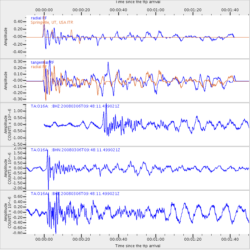
O16A Springville, UT, USA - Earthquake Result Viewer
*The percent match for this event was below the threshold and hence no stack was calculated.
| Earthquake location: |
Kamchatka Peninsula, Russia |
| Earthquake latitude/longitude: |
51.5/156.5 |
| Earthquake time(UTC): |
2008/03/06 (066) 09:38:43 GMT |
| Earthquake Depth: |
134 km |
| Earthquake Magnitude: |
5.6 MB, 5.5 MW, 5.5 MW |
| Earthquake Catalog/Contributor: |
WHDF/NEIC |
|
| Network: |
TA USArray Transportable Network (new EarthScope stations) |
| Station: |
O16A Springville, UT, USA |
| Lat/Lon: |
40.21 N/111.50 W |
| Elevation: |
1789 m |
|
| Distance: |
60.9 deg |
| Az: |
61.124 deg |
| Baz: |
314.409 deg |
| Ray Param: |
$rayparam |
*The percent match for this event was below the threshold and hence was not used in the summary stack. |
|
| Radial Match: |
61.887283 % |
| Radial Bump: |
400 |
| Transverse Match: |
64.28223 % |
| Transverse Bump: |
400 |
| SOD ConfigId: |
2504 |
| Insert Time: |
2010-03-06 00:23:17.810 +0000 |
| GWidth: |
2.5 |
| Max Bumps: |
400 |
| Tol: |
0.001 |
|
Signal To Noise
| Channel | StoN | STA | LTA |
| TA:O16A: :BHN:20080306T09:48:11.499021Z | 4.2957687 | 7.1578313E-7 | 1.6662516E-7 |
| TA:O16A: :BHE:20080306T09:48:11.499021Z | 1.1256917 | 2.5060237E-7 | 2.2262078E-7 |
| TA:O16A: :BHZ:20080306T09:48:11.499021Z | 5.2190423 | 5.718578E-7 | 1.095714E-7 |
| Arrivals |
| Ps | |
| PpPs | |
| PsPs/PpSs | |


