You are here: Home > Network List > TA - USArray Transportable Network (new EarthScope stations) Stations List
> Station O16A Springville, UT, USA > Earthquake Result Viewer
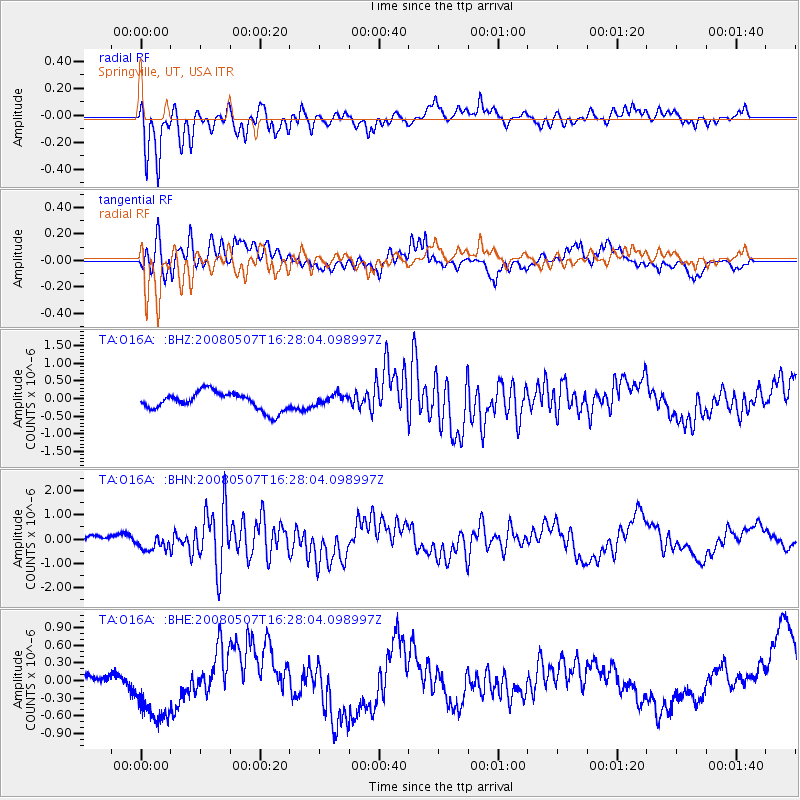
O16A Springville, UT, USA - Earthquake Result Viewer
*The percent match for this event was below the threshold and hence no stack was calculated.
| Earthquake location: |
Near East Coast Of Honshu, Japan |
| Earthquake latitude/longitude: |
36.2/141.8 |
| Earthquake time(UTC): |
2008/05/07 (128) 16:16:36 GMT |
| Earthquake Depth: |
23 km |
| Earthquake Magnitude: |
5.9 MB, 6.1 MW, 6.0 MW |
| Earthquake Catalog/Contributor: |
WHDF/NEIC |
|
| Network: |
TA USArray Transportable Network (new EarthScope stations) |
| Station: |
O16A Springville, UT, USA |
| Lat/Lon: |
40.21 N/111.50 W |
| Elevation: |
1789 m |
|
| Distance: |
78.5 deg |
| Az: |
48.451 deg |
| Baz: |
307.736 deg |
| Ray Param: |
$rayparam |
*The percent match for this event was below the threshold and hence was not used in the summary stack. |
|
| Radial Match: |
66.29319 % |
| Radial Bump: |
400 |
| Transverse Match: |
57.585632 % |
| Transverse Bump: |
400 |
| SOD ConfigId: |
2504 |
| Insert Time: |
2010-03-06 00:23:31.629 +0000 |
| GWidth: |
2.5 |
| Max Bumps: |
400 |
| Tol: |
0.001 |
|
Signal To Noise
| Channel | StoN | STA | LTA |
| TA:O16A: :BHN:20080507T16:28:04.098997Z | 2.032007 | 3.3287884E-7 | 1.6381776E-7 |
| TA:O16A: :BHE:20080507T16:28:04.098997Z | 1.7446052 | 5.6391997E-7 | 3.2323643E-7 |
| TA:O16A: :BHZ:20080507T16:28:04.098997Z | 0.57199925 | 1.4513374E-7 | 2.5373063E-7 |
| Arrivals |
| Ps | |
| PpPs | |
| PsPs/PpSs | |


