You are here: Home > Network List > TA - USArray Transportable Network (new EarthScope stations) Stations List
> Station O16A Springville, UT, USA > Earthquake Result Viewer
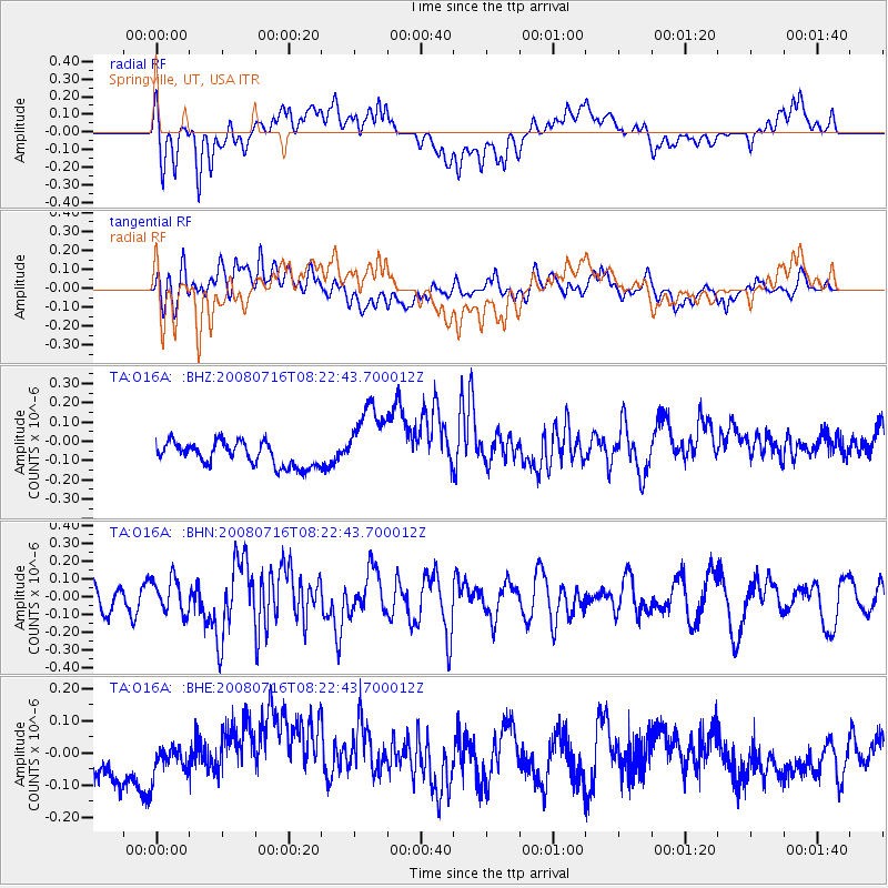
O16A Springville, UT, USA - Earthquake Result Viewer
*The percent match for this event was below the threshold and hence no stack was calculated.
| Earthquake location: |
Samoa Islands Region |
| Earthquake latitude/longitude: |
-16.6/-173.0 |
| Earthquake time(UTC): |
2008/07/16 (198) 08:11:04 GMT |
| Earthquake Depth: |
10 km |
| Earthquake Magnitude: |
5.5 MB, 5.4 MS, 5.7 MW, 5.7 MW |
| Earthquake Catalog/Contributor: |
WHDF/NEIC |
|
| Network: |
TA USArray Transportable Network (new EarthScope stations) |
| Station: |
O16A Springville, UT, USA |
| Lat/Lon: |
40.21 N/111.50 W |
| Elevation: |
1789 m |
|
| Distance: |
80.3 deg |
| Az: |
43.041 deg |
| Baz: |
238.707 deg |
| Ray Param: |
$rayparam |
*The percent match for this event was below the threshold and hence was not used in the summary stack. |
|
| Radial Match: |
38.5488 % |
| Radial Bump: |
400 |
| Transverse Match: |
53.290092 % |
| Transverse Bump: |
400 |
| SOD ConfigId: |
2504 |
| Insert Time: |
2010-03-06 00:23:44.541 +0000 |
| GWidth: |
2.5 |
| Max Bumps: |
400 |
| Tol: |
0.001 |
|
Signal To Noise
| Channel | StoN | STA | LTA |
| TA:O16A: :BHN:20080716T08:22:43.700012Z | 1.434683 | 9.557186E-8 | 6.661532E-8 |
| TA:O16A: :BHE:20080716T08:22:43.700012Z | 0.68687254 | 4.1432838E-8 | 6.0321E-8 |
| TA:O16A: :BHZ:20080716T08:22:43.700012Z | 3.1530533 | 1.9023597E-7 | 6.033389E-8 |
| Arrivals |
| Ps | |
| PpPs | |
| PsPs/PpSs | |


