You are here: Home > Network List > GM - US Geological Survey Networks Stations List
> Station IWM01 Jericho 2M Well Monitoring Station > Earthquake Result Viewer
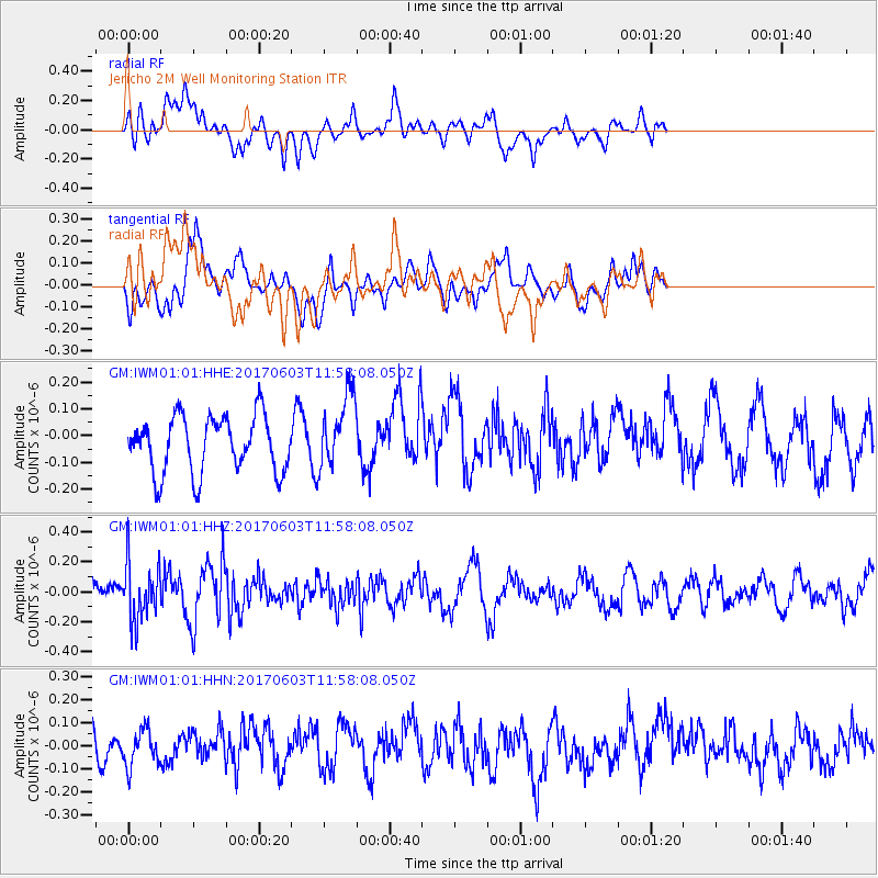
IWM01 Jericho 2M Well Monitoring Station - Earthquake Result Viewer
*The percent match for this event was below the threshold and hence no stack was calculated.
| Earthquake location: |
Kuril Islands |
| Earthquake latitude/longitude: |
50.9/157.3 |
| Earthquake time(UTC): |
2017/06/03 (154) 11:47:23 GMT |
| Earthquake Depth: |
44 km |
| Earthquake Magnitude: |
5.1 Mww |
| Earthquake Catalog/Contributor: |
NEIC PDE/us |
|
| Network: |
GM US Geological Survey Networks |
| Station: |
IWM01 Jericho 2M Well Monitoring Station |
| Lat/Lon: |
36.73 N/96.53 W |
| Elevation: |
328 m |
|
| Distance: |
71.4 deg |
| Az: |
54.487 deg |
| Baz: |
320.06 deg |
| Ray Param: |
$rayparam |
*The percent match for this event was below the threshold and hence was not used in the summary stack. |
|
| Radial Match: |
47.15162 % |
| Radial Bump: |
400 |
| Transverse Match: |
72.04484 % |
| Transverse Bump: |
400 |
| SOD ConfigId: |
13570011 |
| Insert Time: |
2019-04-28 03:26:12.652 +0000 |
| GWidth: |
2.5 |
| Max Bumps: |
400 |
| Tol: |
0.001 |
|
Signal To Noise
| Channel | StoN | STA | LTA |
| GM:IWM01:01:HHZ:20170603T11:58:08.050Z | 1.7822778 | 1.9390592E-7 | 1.08796684E-7 |
| GM:IWM01:01:HHN:20170603T11:58:08.050Z | 1.1619074 | 8.359715E-8 | 7.194821E-8 |
| GM:IWM01:01:HHE:20170603T11:58:08.050Z | 1.3289953 | 1.3859527E-7 | 1.0428574E-7 |
| Arrivals |
| Ps | |
| PpPs | |
| PsPs/PpSs | |


