You are here: Home > Network List > TA - USArray Transportable Network (new EarthScope stations) Stations List
> Station TIGA Tifton, GA, USA > Earthquake Result Viewer
TIGA Tifton, GA, USA - Earthquake Result Viewer
| Earthquake location: |
Kuril Islands |
| Earthquake latitude/longitude: |
46.0/151.4 |
| Earthquake time(UTC): |
2009/04/18 (108) 19:17:58 GMT |
| Earthquake Depth: |
35 km |
| Earthquake Magnitude: |
6.3 MB, 6.3 MS, 6.6 MW, 6.4 MW |
| Earthquake Catalog/Contributor: |
WHDF/NEIC |
|
| Network: |
TA USArray Transportable Network (new EarthScope stations) |
| Station: |
TIGA Tifton, GA, USA |
| Lat/Lon: |
31.44 N/83.59 W |
| Elevation: |
109 m |
|
| Distance: |
88.2 deg |
| Az: |
44.479 deg |
| Baz: |
325.163 deg |
| Ray Param: |
0.042688366 |
| Estimated Moho Depth: |
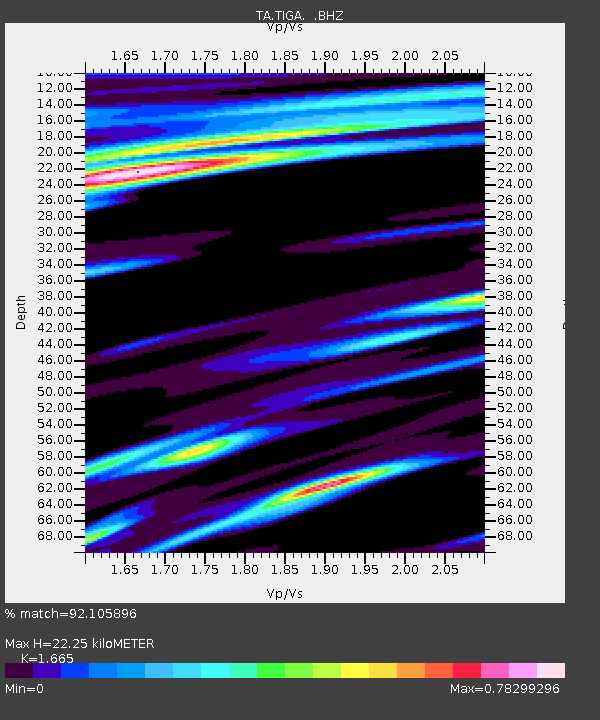
22.25 km |
| Estimated Crust Vp/Vs: |
1.66 |
| Assumed Crust Vp: |
6.565 km/s |
| Estimated Crust Vs: |
3.943 km/s |
| Estimated Crust Poisson's Ratio: |
0.22 |
|
| Radial Match: |
92.105896 % |
| Radial Bump: |
293 |
| Transverse Match: |
69.54686 % |
| Transverse Bump: |
348 |
| SOD ConfigId: |
2760 |
| Insert Time: |
2010-03-06 00:23:52.727 +0000 |
| GWidth: |
2.5 |
| Max Bumps: |
400 |
| Tol: |
0.001 |
|

Signal To Noise
| Channel | StoN | STA | LTA |
| TA:TIGA: :BHZ:20090418T19:30:15.32502Z | 6.0985193 | 3.0428903E-6 | 4.989556E-7 |
| TA:TIGA: :BHN:20090418T19:30:15.32502Z | 1.5688858 | 5.7453457E-7 | 3.6620548E-7 |
| TA:TIGA: :BHE:20090418T19:30:15.32502Z | 1.0406578 | 4.498314E-7 | 4.322568E-7 |
| Arrivals |
| Ps | 2.3 SECOND |
| PpPs | 8.8 SECOND |
| PsPs/PpSs | 11 SECOND |


