You are here: Home > Network List > TA - USArray Transportable Network (new EarthScope stations) Stations List
> Station TIGA Tifton, GA, USA > Earthquake Result Viewer
TIGA Tifton, GA, USA - Earthquake Result Viewer
| Earthquake location: |
Norwegian Sea |
| Earthquake latitude/longitude: |
72.2/0.9 |
| Earthquake time(UTC): |
2009/08/20 (232) 06:35:04 GMT |
| Earthquake Depth: |
6.0 km |
| Earthquake Magnitude: |
5.9 MB, 5.7 MS, 6.0 MW, 6.0 MW |
| Earthquake Catalog/Contributor: |
WHDF/NEIC |
|
| Network: |
TA USArray Transportable Network (new EarthScope stations) |
| Station: |
TIGA Tifton, GA, USA |
| Lat/Lon: |
31.44 N/83.59 W |
| Elevation: |
109 m |
|
| Distance: |
58.7 deg |
| Az: |
275.516 deg |
| Baz: |
20.987 deg |
| Ray Param: |
0.062656805 |
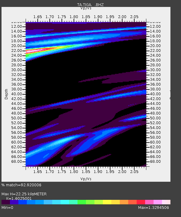
| Estimated Moho Depth: |
22.25 km |
| Estimated Crust Vp/Vs: |
1.60 |
| Assumed Crust Vp: |
6.565 km/s |
| Estimated Crust Vs: |
4.096 km/s |
| Estimated Crust Poisson's Ratio: |
0.18 |
|
| Radial Match: |
92.920006 % |
| Radial Bump: |
342 |
| Transverse Match: |
75.33076 % |
| Transverse Bump: |
400 |
| SOD ConfigId: |
2622 |
| Insert Time: |
2010-03-06 00:23:58.231 +0000 |
| GWidth: |
2.5 |
| Max Bumps: |
400 |
| Tol: |
0.001 |
|

Signal To Noise
| Channel | StoN | STA | LTA |
| TA:TIGA: :BHZ:20090820T06:44:31.924019Z | 12.311086 | 1.9291754E-6 | 1.567023E-7 |
| TA:TIGA: :BHN:20090820T06:44:31.924019Z | 3.6361768 | 5.9118844E-7 | 1.6258517E-7 |
| TA:TIGA: :BHE:20090820T06:44:31.924019Z | 1.5209197 | 3.5266072E-7 | 2.3187334E-7 |
| Arrivals |
| Ps | 2.2 SECOND |
| PpPs | 8.3 SECOND |
| PsPs/PpSs | 10 SECOND |


