You are here: Home > Network List > IU - Global Seismograph Network (GSN - IRIS/USGS) Stations List
> Station PMG Port Moresby, New Guinea > Earthquake Result Viewer
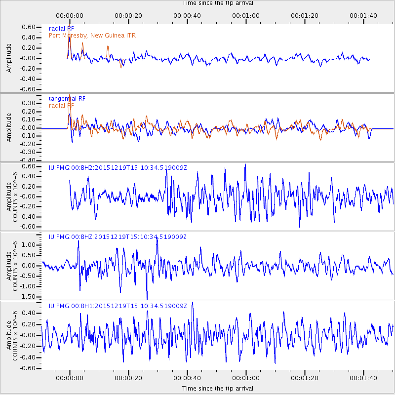
PMG Port Moresby, New Guinea - Earthquake Result Viewer
*The percent match for this event was below the threshold and hence no stack was calculated.
| Earthquake location: |
Java, Indonesia |
| Earthquake latitude/longitude: |
-8.4/107.0 |
| Earthquake time(UTC): |
2015/12/19 (353) 15:03:34 GMT |
| Earthquake Depth: |
20 km |
| Earthquake Magnitude: |
5.6 MB |
| Earthquake Catalog/Contributor: |
NEIC PDE/NEIC COMCAT |
|
| Network: |
IU Global Seismograph Network (GSN - IRIS/USGS) |
| Station: |
PMG Port Moresby, New Guinea |
| Lat/Lon: |
9.40 S/147.16 E |
| Elevation: |
90 m |
|
| Distance: |
39.6 deg |
| Az: |
94.596 deg |
| Baz: |
268.168 deg |
| Ray Param: |
$rayparam |
*The percent match for this event was below the threshold and hence was not used in the summary stack. |
|
| Radial Match: |
64.04896 % |
| Radial Bump: |
400 |
| Transverse Match: |
59.06711 % |
| Transverse Bump: |
400 |
| SOD ConfigId: |
1259291 |
| Insert Time: |
2016-01-02 15:22:12.904 +0000 |
| GWidth: |
2.5 |
| Max Bumps: |
400 |
| Tol: |
0.001 |
|
Signal To Noise
| Channel | StoN | STA | LTA |
| IU:PMG:00:BHZ:20151219T15:10:34.519009Z | 3.3743896 | 4.2608238E-7 | 1.2626947E-7 |
| IU:PMG:00:BH1:20151219T15:10:34.519009Z | 1.0691556 | 1.4959622E-7 | 1.3991998E-7 |
| IU:PMG:00:BH2:20151219T15:10:34.519009Z | 1.445082 | 2.0783177E-7 | 1.4382006E-7 |
| Arrivals |
| Ps | |
| PpPs | |
| PsPs/PpSs | |


