You are here: Home > Network List > TA - USArray Transportable Network (new EarthScope stations) Stations List
> Station T31A Randall Ranch, Ashland, KS, USA > Earthquake Result Viewer
T31A Randall Ranch, Ashland, KS, USA - Earthquake Result Viewer
| Earthquake location: |
Samoa Islands Region |
| Earthquake latitude/longitude: |
-15.5/-172.1 |
| Earthquake time(UTC): |
2009/09/29 (272) 17:48:10 GMT |
| Earthquake Depth: |
18 km |
| Earthquake Magnitude: |
7.1 MB, 8.1 MS, 8.1 MW, 8.0 MW |
| Earthquake Catalog/Contributor: |
WHDF/NEIC |
|
| Network: |
TA USArray Transportable Network (new EarthScope stations) |
| Station: |
T31A Randall Ranch, Ashland, KS, USA |
| Lat/Lon: |
37.10 N/99.68 W |
| Elevation: |
564 m |
|
| Distance: |
85.8 deg |
| Az: |
49.842 deg |
| Baz: |
247.16 deg |
| Ray Param: |
0.044500344 |
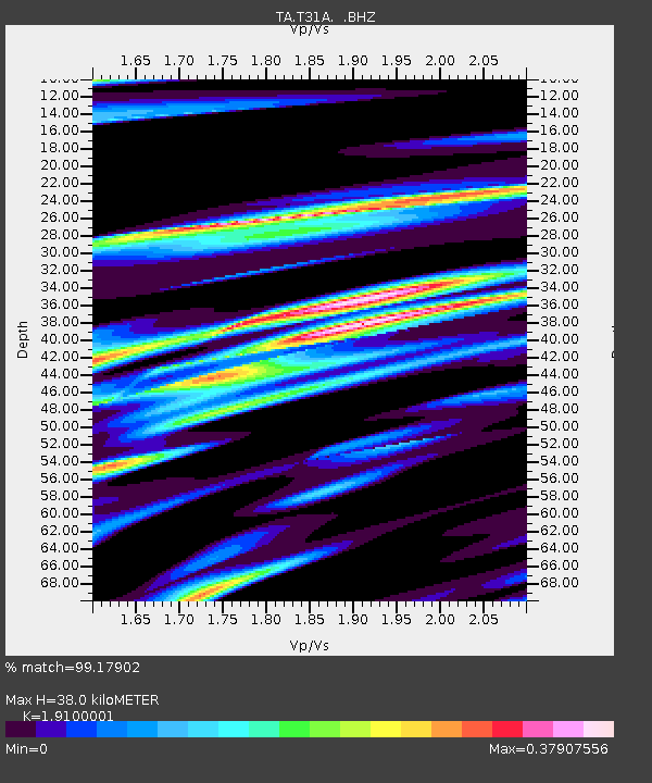
| Estimated Moho Depth: |
38.0 km |
| Estimated Crust Vp/Vs: |
1.91 |
| Assumed Crust Vp: |
6.426 km/s |
| Estimated Crust Vs: |
3.364 km/s |
| Estimated Crust Poisson's Ratio: |
0.31 |
|
| Radial Match: |
99.17902 % |
| Radial Bump: |
261 |
| Transverse Match: |
93.52717 % |
| Transverse Bump: |
400 |
| SOD ConfigId: |
2622 |
| Insert Time: |
2010-03-06 00:24:51.970 +0000 |
| GWidth: |
2.5 |
| Max Bumps: |
400 |
| Tol: |
0.001 |
|
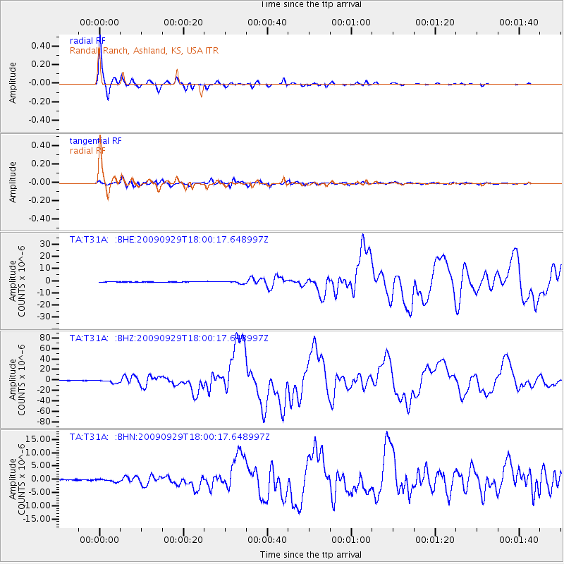
Signal To Noise
| Channel | StoN | STA | LTA |
| TA:T31A: :BHZ:20090929T18:00:17.648997Z | 19.161093 | 3.1650452E-6 | 1.6518082E-7 |
| TA:T31A: :BHN:20090929T18:00:17.648997Z | 2.3322034 | 4.8781374E-7 | 2.0916431E-7 |
| TA:T31A: :BHE:20090929T18:00:17.648997Z | 6.428755 | 9.861811E-7 | 1.5340157E-7 |
| Arrivals |
| Ps | 5.5 SECOND |
| PpPs | 17 SECOND |
| PsPs/PpSs | 22 SECOND |


