You are here: Home > Network List > TA - USArray Transportable Network (new EarthScope stations) Stations List
> Station D23K Nanushuk River, AK USA > Earthquake Result Viewer
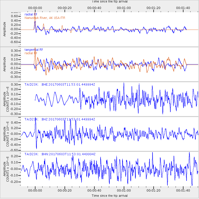
D23K Nanushuk River, AK USA - Earthquake Result Viewer
*The percent match for this event was below the threshold and hence no stack was calculated.
| Earthquake location: |
Kuril Islands |
| Earthquake latitude/longitude: |
50.9/157.3 |
| Earthquake time(UTC): |
2017/06/03 (154) 11:47:23 GMT |
| Earthquake Depth: |
44 km |
| Earthquake Magnitude: |
5.1 Mww |
| Earthquake Catalog/Contributor: |
NEIC PDE/us |
|
| Network: |
TA USArray Transportable Network (new EarthScope stations) |
| Station: |
D23K Nanushuk River, AK USA |
| Lat/Lon: |
68.97 N/150.68 W |
| Elevation: |
406 m |
|
| Distance: |
30.4 deg |
| Az: |
34.184 deg |
| Baz: |
260.439 deg |
| Ray Param: |
$rayparam |
*The percent match for this event was below the threshold and hence was not used in the summary stack. |
|
| Radial Match: |
69.34679 % |
| Radial Bump: |
400 |
| Transverse Match: |
65.56939 % |
| Transverse Bump: |
400 |
| SOD ConfigId: |
13570011 |
| Insert Time: |
2019-04-28 03:31:06.388 +0000 |
| GWidth: |
2.5 |
| Max Bumps: |
400 |
| Tol: |
0.001 |
|
Signal To Noise
| Channel | StoN | STA | LTA |
| TA:D23K: :BHZ:20170603T11:53:01.449994Z | 3.7086062 | 2.3814663E-7 | 6.421459E-8 |
| TA:D23K: :BHN:20170603T11:53:01.449994Z | 1.2183205 | 5.5144977E-8 | 4.5263114E-8 |
| TA:D23K: :BHE:20170603T11:53:01.449994Z | 1.3758881 | 9.717029E-8 | 7.0623685E-8 |
| Arrivals |
| Ps | |
| PpPs | |
| PsPs/PpSs | |


