You are here: Home > Network List > TA - USArray Transportable Network (new EarthScope stations) Stations List
> Station J25K Salcha River, AK, USA > Earthquake Result Viewer
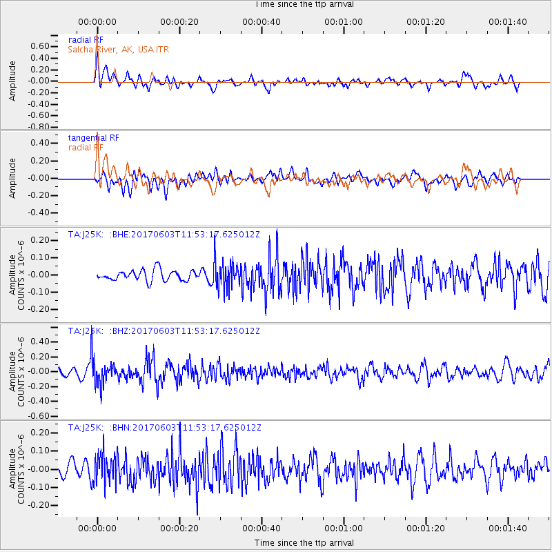
J25K Salcha River, AK, USA - Earthquake Result Viewer
*The percent match for this event was below the threshold and hence no stack was calculated.
| Earthquake location: |
Kuril Islands |
| Earthquake latitude/longitude: |
50.9/157.3 |
| Earthquake time(UTC): |
2017/06/03 (154) 11:47:23 GMT |
| Earthquake Depth: |
44 km |
| Earthquake Magnitude: |
5.1 Mww |
| Earthquake Catalog/Contributor: |
NEIC PDE/us |
|
| Network: |
TA USArray Transportable Network (new EarthScope stations) |
| Station: |
J25K Salcha River, AK, USA |
| Lat/Lon: |
64.61 N/145.37 W |
| Elevation: |
949 m |
|
| Distance: |
32.3 deg |
| Az: |
42.81 deg |
| Baz: |
272.689 deg |
| Ray Param: |
$rayparam |
*The percent match for this event was below the threshold and hence was not used in the summary stack. |
|
| Radial Match: |
67.95146 % |
| Radial Bump: |
400 |
| Transverse Match: |
56.381977 % |
| Transverse Bump: |
400 |
| SOD ConfigId: |
13570011 |
| Insert Time: |
2019-04-28 03:31:26.837 +0000 |
| GWidth: |
2.5 |
| Max Bumps: |
400 |
| Tol: |
0.001 |
|
Signal To Noise
| Channel | StoN | STA | LTA |
| TA:J25K: :BHZ:20170603T11:53:17.625012Z | 3.2677758 | 1.3097812E-7 | 4.0081737E-8 |
| TA:J25K: :BHN:20170603T11:53:17.625012Z | 1.8925006 | 7.815397E-8 | 4.1296666E-8 |
| TA:J25K: :BHE:20170603T11:53:17.625012Z | 2.1688437 | 6.608421E-8 | 3.0469792E-8 |
| Arrivals |
| Ps | |
| PpPs | |
| PsPs/PpSs | |


