You are here: Home > Network List > TA - USArray Transportable Network (new EarthScope stations) Stations List
> Station N23A Red Feather Lakes, CO, USA > Earthquake Result Viewer
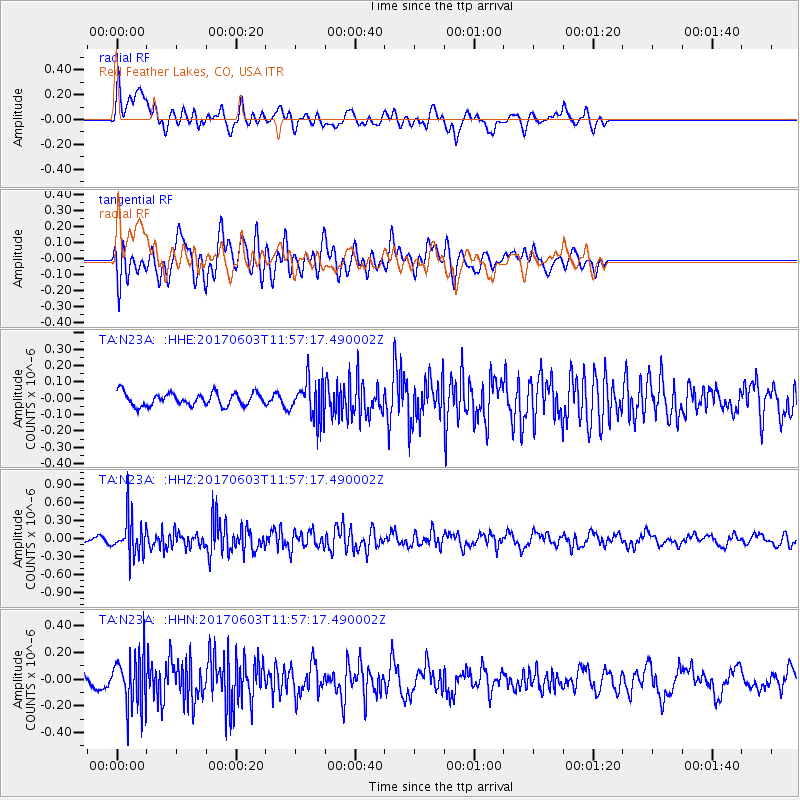
N23A Red Feather Lakes, CO, USA - Earthquake Result Viewer
*The percent match for this event was below the threshold and hence no stack was calculated.
| Earthquake location: |
Kuril Islands |
| Earthquake latitude/longitude: |
50.9/157.3 |
| Earthquake time(UTC): |
2017/06/03 (154) 11:47:23 GMT |
| Earthquake Depth: |
44 km |
| Earthquake Magnitude: |
5.1 Mww |
| Earthquake Catalog/Contributor: |
NEIC PDE/us |
|
| Network: |
TA USArray Transportable Network (new EarthScope stations) |
| Station: |
N23A Red Feather Lakes, CO, USA |
| Lat/Lon: |
40.89 N/105.94 W |
| Elevation: |
2458 m |
|
| Distance: |
63.4 deg |
| Az: |
57.344 deg |
| Baz: |
315.273 deg |
| Ray Param: |
$rayparam |
*The percent match for this event was below the threshold and hence was not used in the summary stack. |
|
| Radial Match: |
55.371185 % |
| Radial Bump: |
400 |
| Transverse Match: |
61.815224 % |
| Transverse Bump: |
400 |
| SOD ConfigId: |
13570011 |
| Insert Time: |
2019-04-28 03:31:39.719 +0000 |
| GWidth: |
2.5 |
| Max Bumps: |
400 |
| Tol: |
0.001 |
|
Signal To Noise
| Channel | StoN | STA | LTA |
| TA:N23A: :HHZ:20170603T11:57:17.490002Z | 7.9031243 | 3.1522018E-7 | 3.9885517E-8 |
| TA:N23A: :HHN:20170603T11:57:17.490002Z | 3.7643204 | 2.0016633E-7 | 5.3174627E-8 |
| TA:N23A: :HHE:20170603T11:57:17.490002Z | 2.991428 | 1.1659751E-7 | 3.8977205E-8 |
| Arrivals |
| Ps | |
| PpPs | |
| PsPs/PpSs | |


