You are here: Home > Network List > TJ - Tajikistan National Seismic Network Stations List
> Station GARM Garm, Tajikistan > Earthquake Result Viewer
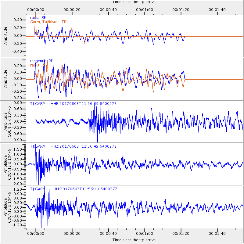
GARM Garm, Tajikistan - Earthquake Result Viewer
*The percent match for this event was below the threshold and hence no stack was calculated.
| Earthquake location: |
Kuril Islands |
| Earthquake latitude/longitude: |
50.9/157.3 |
| Earthquake time(UTC): |
2017/06/03 (154) 11:47:23 GMT |
| Earthquake Depth: |
44 km |
| Earthquake Magnitude: |
5.1 Mww |
| Earthquake Catalog/Contributor: |
NEIC PDE/us |
|
| Network: |
TJ Tajikistan National Seismic Network |
| Station: |
GARM Garm, Tajikistan |
| Lat/Lon: |
39.00 N/70.32 E |
| Elevation: |
1305 m |
|
| Distance: |
59.3 deg |
| Az: |
295.142 deg |
| Baz: |
47.405 deg |
| Ray Param: |
$rayparam |
*The percent match for this event was below the threshold and hence was not used in the summary stack. |
|
| Radial Match: |
59.900494 % |
| Radial Bump: |
400 |
| Transverse Match: |
67.11364 % |
| Transverse Bump: |
400 |
| SOD ConfigId: |
13570011 |
| Insert Time: |
2019-04-28 03:32:08.023 +0000 |
| GWidth: |
2.5 |
| Max Bumps: |
400 |
| Tol: |
0.001 |
|
Signal To Noise
| Channel | StoN | STA | LTA |
| TJ:GARM: :HHZ:20170603T11:56:49.640027Z | 10.681552 | 8.837893E-7 | 8.273979E-8 |
| TJ:GARM: :HHN:20170603T11:56:49.640027Z | 4.6376324 | 4.5202387E-7 | 9.746867E-8 |
| TJ:GARM: :HHE:20170603T11:56:49.640027Z | 4.9267755 | 3.712119E-7 | 7.534582E-8 |
| Arrivals |
| Ps | |
| PpPs | |
| PsPs/PpSs | |


