You are here: Home > Network List > UW - Pacific Northwest Regional Seismic Network Stations List
> Station UMAT Pilot Rock, OR, USA > Earthquake Result Viewer
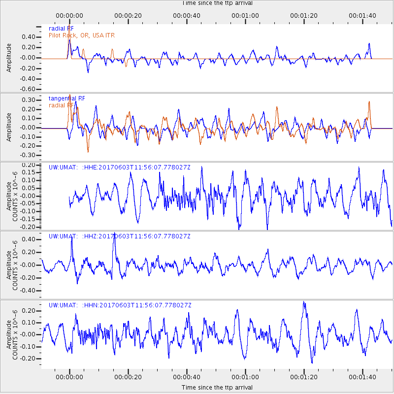
UMAT Pilot Rock, OR, USA - Earthquake Result Viewer
*The percent match for this event was below the threshold and hence no stack was calculated.
| Earthquake location: |
Kuril Islands |
| Earthquake latitude/longitude: |
50.9/157.3 |
| Earthquake time(UTC): |
2017/06/03 (154) 11:47:23 GMT |
| Earthquake Depth: |
44 km |
| Earthquake Magnitude: |
5.1 Mww |
| Earthquake Catalog/Contributor: |
NEIC PDE/us |
|
| Network: |
UW Pacific Northwest Regional Seismic Network |
| Station: |
UMAT Pilot Rock, OR, USA |
| Lat/Lon: |
45.29 N/118.96 W |
| Elevation: |
1318 m |
|
| Distance: |
53.4 deg |
| Az: |
60.967 deg |
| Baz: |
308.293 deg |
| Ray Param: |
$rayparam |
*The percent match for this event was below the threshold and hence was not used in the summary stack. |
|
| Radial Match: |
63.988724 % |
| Radial Bump: |
400 |
| Transverse Match: |
55.517822 % |
| Transverse Bump: |
400 |
| SOD ConfigId: |
13570011 |
| Insert Time: |
2019-04-28 03:32:44.599 +0000 |
| GWidth: |
2.5 |
| Max Bumps: |
400 |
| Tol: |
0.001 |
|
Signal To Noise
| Channel | StoN | STA | LTA |
| UW:UMAT: :HHZ:20170603T11:56:07.778027Z | 2.5837464 | 1.5246312E-7 | 5.9008542E-8 |
| UW:UMAT: :HHN:20170603T11:56:07.778027Z | 1.4604479 | 9.0838846E-8 | 6.2199305E-8 |
| UW:UMAT: :HHE:20170603T11:56:07.778027Z | 0.8724726 | 5.681341E-8 | 6.5117696E-8 |
| Arrivals |
| Ps | |
| PpPs | |
| PsPs/PpSs | |


