You are here: Home > Network List > TA - USArray Transportable Network (new EarthScope stations) Stations List
> Station U30A WK&E Inc., Balko, OK, USA > Earthquake Result Viewer
U30A WK&E Inc., Balko, OK, USA - Earthquake Result Viewer
| Earthquake location: |
Samoa Islands Region |
| Earthquake latitude/longitude: |
-15.2/-172.6 |
| Earthquake time(UTC): |
2009/08/30 (242) 14:51:32 GMT |
| Earthquake Depth: |
11 km |
| Earthquake Magnitude: |
6.4 MB, 6.3 MS, 6.6 MW, 6.6 MW |
| Earthquake Catalog/Contributor: |
WHDF/NEIC |
|
| Network: |
TA USArray Transportable Network (new EarthScope stations) |
| Station: |
U30A WK&E Inc., Balko, OK, USA |
| Lat/Lon: |
36.53 N/100.65 W |
| Elevation: |
881 m |
|
| Distance: |
85.0 deg |
| Az: |
50.226 deg |
| Baz: |
247.096 deg |
| Ray Param: |
0.045056667 |
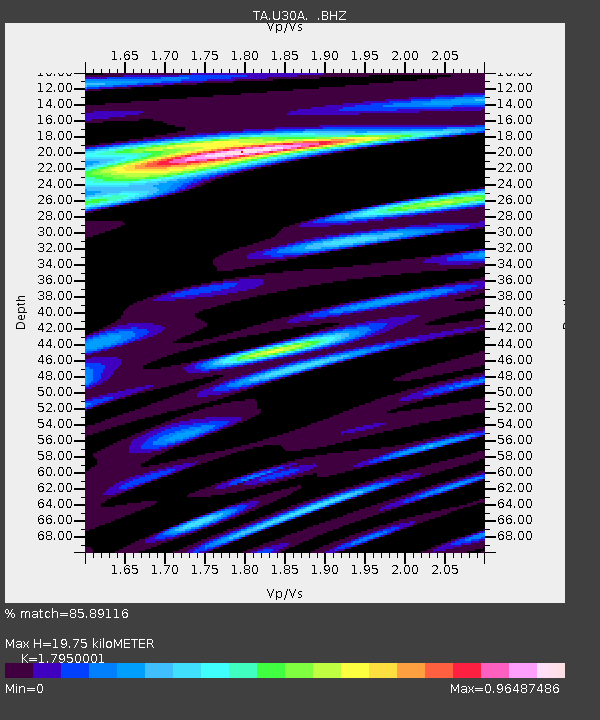
| Estimated Moho Depth: |
19.75 km |
| Estimated Crust Vp/Vs: |
1.80 |
| Assumed Crust Vp: |
6.483 km/s |
| Estimated Crust Vs: |
3.611 km/s |
| Estimated Crust Poisson's Ratio: |
0.27 |
|
| Radial Match: |
85.89116 % |
| Radial Bump: |
400 |
| Transverse Match: |
83.03671 % |
| Transverse Bump: |
400 |
| SOD ConfigId: |
2622 |
| Insert Time: |
2010-03-06 00:25:48.566 +0000 |
| GWidth: |
2.5 |
| Max Bumps: |
400 |
| Tol: |
0.001 |
|

Signal To Noise
| Channel | StoN | STA | LTA |
| TA:U30A: :BHZ:20090830T15:03:36.874009Z | 22.368498 | 3.799462E-6 | 1.6985771E-7 |
| TA:U30A: :BHN:20090830T15:03:36.874009Z | 1.2838793 | 3.7112855E-7 | 2.890681E-7 |
| TA:U30A: :BHE:20090830T15:03:36.874009Z | 7.9945 | 1.158818E-6 | 1.449519E-7 |
| Arrivals |
| Ps | 2.5 SECOND |
| PpPs | 8.3 SECOND |
| PsPs/PpSs | 11 SECOND |


