You are here: Home > Network List > GS - US Geological Survey Networks Stations List
> Station KAN11 Stewart Ranch, Harper County, KS, USA > Earthquake Result Viewer
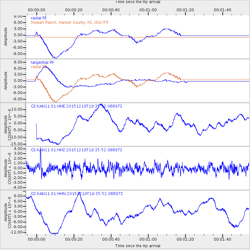
KAN11 Stewart Ranch, Harper County, KS, USA - Earthquake Result Viewer
*The percent match for this event was below the threshold and hence no stack was calculated.
| Earthquake location: |
Near Coast Of Central Chile |
| Earthquake latitude/longitude: |
-30.6/-71.4 |
| Earthquake time(UTC): |
2015/12/19 (353) 19:25:04 GMT |
| Earthquake Depth: |
46 km |
| Earthquake Magnitude: |
5.8 MWR |
| Earthquake Catalog/Contributor: |
NEIC PDE/NEIC COMCAT |
|
| Network: |
GS US Geological Survey Networks |
| Station: |
KAN11 Stewart Ranch, Harper County, KS, USA |
| Lat/Lon: |
37.21 N/97.91 W |
| Elevation: |
410 m |
|
| Distance: |
71.9 deg |
| Az: |
337.955 deg |
| Baz: |
156.1 deg |
| Ray Param: |
$rayparam |
*The percent match for this event was below the threshold and hence was not used in the summary stack. |
|
| Radial Match: |
64.267624 % |
| Radial Bump: |
400 |
| Transverse Match: |
48.177475 % |
| Transverse Bump: |
400 |
| SOD ConfigId: |
1259291 |
| Insert Time: |
2016-01-02 19:38:43.565 +0000 |
| GWidth: |
2.5 |
| Max Bumps: |
400 |
| Tol: |
0.001 |
|
Signal To Noise
| Channel | StoN | STA | LTA |
| GS:KAN11:01:HHZ:20151219T19:35:52.08897Z | 2.9015229 | 1.2762346E-6 | 4.398499E-7 |
| GS:KAN11:01:HHN:20151219T19:35:52.08897Z | 2.3422427 | 8.6617E-6 | 3.698037E-6 |
| GS:KAN11:01:HHE:20151219T19:35:52.08897Z | 2.8765051 | 1.7964929E-5 | 6.245401E-6 |
| Arrivals |
| Ps | |
| PpPs | |
| PsPs/PpSs | |


