You are here: Home > Network List > CI - Caltech Regional Seismic Network Stations List
> Station MPM Manuel Prospect Mine, California, USA > Earthquake Result Viewer
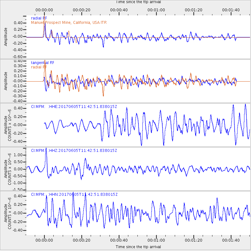
MPM Manuel Prospect Mine, California, USA - Earthquake Result Viewer
*The percent match for this event was below the threshold and hence no stack was calculated.
| Earthquake location: |
Peru-Ecuador Border Region |
| Earthquake latitude/longitude: |
-4.1/-80.4 |
| Earthquake time(UTC): |
2017/06/05 (156) 11:34:11 GMT |
| Earthquake Depth: |
51 km |
| Earthquake Magnitude: |
5.6 Mww |
| Earthquake Catalog/Contributor: |
NEIC PDE/us |
|
| Network: |
CI Caltech Regional Seismic Network |
| Station: |
MPM Manuel Prospect Mine, California, USA |
| Lat/Lon: |
36.06 N/117.49 W |
| Elevation: |
185 m |
|
| Distance: |
52.9 deg |
| Az: |
322.212 deg |
| Baz: |
131.038 deg |
| Ray Param: |
$rayparam |
*The percent match for this event was below the threshold and hence was not used in the summary stack. |
|
| Radial Match: |
79.19845 % |
| Radial Bump: |
400 |
| Transverse Match: |
68.92802 % |
| Transverse Bump: |
400 |
| SOD ConfigId: |
13570011 |
| Insert Time: |
2019-04-28 03:38:22.337 +0000 |
| GWidth: |
2.5 |
| Max Bumps: |
400 |
| Tol: |
0.001 |
|
Signal To Noise
| Channel | StoN | STA | LTA |
| CI:MPM: :HHZ:20170605T11:42:51.838015Z | 4.281072 | 5.7801395E-7 | 1.3501617E-7 |
| CI:MPM: :HHN:20170605T11:42:51.838015Z | 2.7917914 | 2.1150305E-7 | 7.57589E-8 |
| CI:MPM: :HHE:20170605T11:42:51.838015Z | 2.5661745 | 2.0218319E-7 | 7.878778E-8 |
| Arrivals |
| Ps | |
| PpPs | |
| PsPs/PpSs | |


