You are here: Home > Network List > CI - Caltech Regional Seismic Network Stations List
> Station SMM Simmler, CA, USA > Earthquake Result Viewer
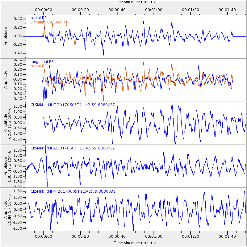
SMM Simmler, CA, USA - Earthquake Result Viewer
*The percent match for this event was below the threshold and hence no stack was calculated.
| Earthquake location: |
Peru-Ecuador Border Region |
| Earthquake latitude/longitude: |
-4.1/-80.4 |
| Earthquake time(UTC): |
2017/06/05 (156) 11:34:11 GMT |
| Earthquake Depth: |
51 km |
| Earthquake Magnitude: |
5.6 Mww |
| Earthquake Catalog/Contributor: |
NEIC PDE/us |
|
| Network: |
CI Caltech Regional Seismic Network |
| Station: |
SMM Simmler, CA, USA |
| Lat/Lon: |
35.31 N/120.00 W |
| Elevation: |
599 m |
|
| Distance: |
54.0 deg |
| Az: |
319.881 deg |
| Baz: |
128.194 deg |
| Ray Param: |
$rayparam |
*The percent match for this event was below the threshold and hence was not used in the summary stack. |
|
| Radial Match: |
44.918373 % |
| Radial Bump: |
400 |
| Transverse Match: |
59.590397 % |
| Transverse Bump: |
400 |
| SOD ConfigId: |
13570011 |
| Insert Time: |
2019-04-28 03:38:33.894 +0000 |
| GWidth: |
2.5 |
| Max Bumps: |
400 |
| Tol: |
0.001 |
|
Signal To Noise
| Channel | StoN | STA | LTA |
| CI:SMM: :HHZ:20170605T11:42:59.888003Z | 3.0179074 | 8.098149E-7 | 2.6833658E-7 |
| CI:SMM: :HHN:20170605T11:42:59.888003Z | 1.5212792 | 5.301713E-7 | 3.4850362E-7 |
| CI:SMM: :HHE:20170605T11:42:59.888003Z | 1.1754311 | 3.872874E-7 | 3.294854E-7 |
| Arrivals |
| Ps | |
| PpPs | |
| PsPs/PpSs | |


