You are here: Home > Network List > CI - Caltech Regional Seismic Network Stations List
> Station SWS Sam W. Stewart, Westmorland, CA, USA > Earthquake Result Viewer
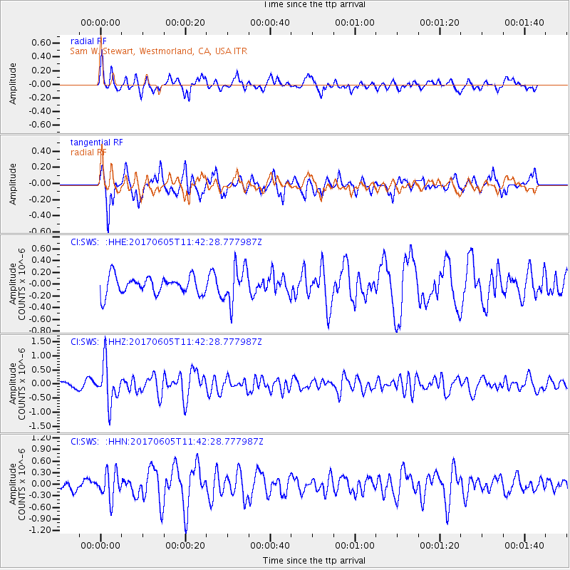
SWS Sam W. Stewart, Westmorland, CA, USA - Earthquake Result Viewer
*The percent match for this event was below the threshold and hence no stack was calculated.
| Earthquake location: |
Peru-Ecuador Border Region |
| Earthquake latitude/longitude: |
-4.1/-80.4 |
| Earthquake time(UTC): |
2017/06/05 (156) 11:34:11 GMT |
| Earthquake Depth: |
51 km |
| Earthquake Magnitude: |
5.6 Mww |
| Earthquake Catalog/Contributor: |
NEIC PDE/us |
|
| Network: |
CI Caltech Regional Seismic Network |
| Station: |
SWS Sam W. Stewart, Westmorland, CA, USA |
| Lat/Lon: |
32.94 N/115.80 W |
| Elevation: |
140 m |
|
| Distance: |
49.8 deg |
| Az: |
320.379 deg |
| Baz: |
130.848 deg |
| Ray Param: |
$rayparam |
*The percent match for this event was below the threshold and hence was not used in the summary stack. |
|
| Radial Match: |
68.55424 % |
| Radial Bump: |
383 |
| Transverse Match: |
71.280685 % |
| Transverse Bump: |
369 |
| SOD ConfigId: |
13570011 |
| Insert Time: |
2019-04-28 03:38:36.578 +0000 |
| GWidth: |
2.5 |
| Max Bumps: |
400 |
| Tol: |
0.001 |
|
Signal To Noise
| Channel | StoN | STA | LTA |
| CI:SWS: :HHZ:20170605T11:42:28.777987Z | 6.0811644 | 7.1903753E-7 | 1.182401E-7 |
| CI:SWS: :HHN:20170605T11:42:28.777987Z | 2.885903 | 3.4948408E-7 | 1.2110043E-7 |
| CI:SWS: :HHE:20170605T11:42:28.777987Z | 2.075933 | 3.133091E-7 | 1.5092446E-7 |
| Arrivals |
| Ps | |
| PpPs | |
| PsPs/PpSs | |


