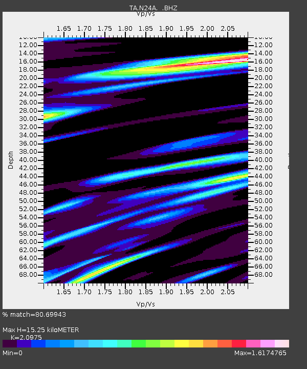
N24A Carr, CO, USA - Earthquake Result Viewer
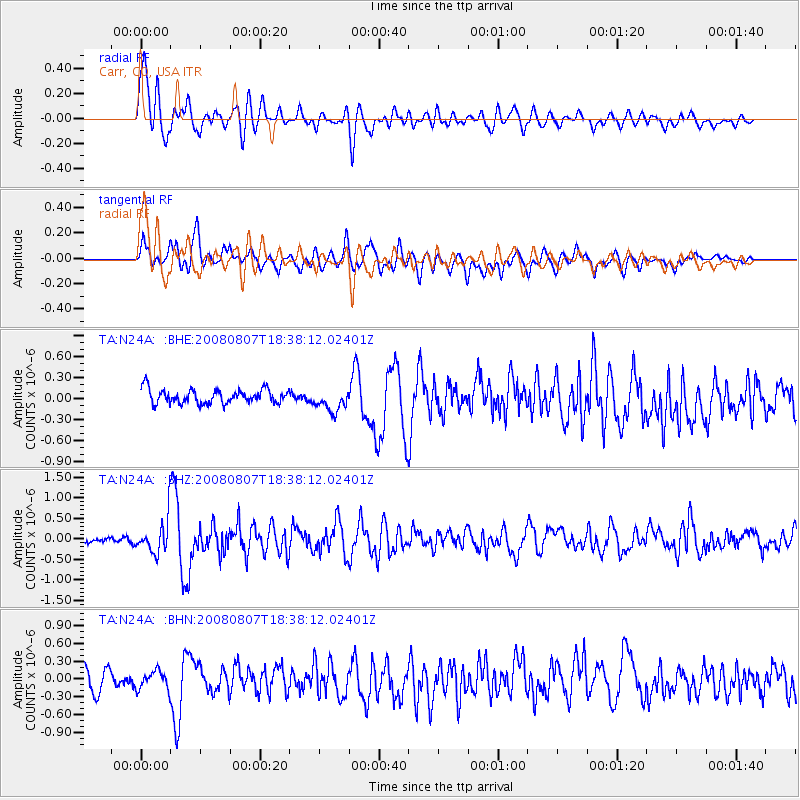
Earthquake location: Andreanof Islands, Aleutian Is.
Earthquake latitude/longitude: 52.2/-175.7
Earthquake time(UTC): 2008/08/07 (220) 18:30:03 GMT
Earthquake Depth: 12 km
Earthquake Magnitude: 5.6 MB, 5.5 MS, 5.8 MW, 5.8 MW
Earthquake Catalog/Contributor: WHDF/NEIC
Network: TA USArray Transportable Network (new EarthScope stations)
Station: N24A Carr, CO, USA
Lat/Lon: 40.83 N/104.88 W
Elevation: 1695 m
Distance: 48.2 deg
Az: 74.111 deg
Baz: 308.717 deg
Ray Param: 0.069533944
Estimated Moho Depth: 15.25 km
Estimated Crust Vp/Vs: 2.10
Assumed Crust Vp: 6.306 km/s
Estimated Crust Vs: 3.006 km/s
Estimated Crust Poisson's Ratio: 0.35
Radial Match: 80.69943 %
Radial Bump: 400
Transverse Match: 67.18714 %
Transverse Bump: 400
SOD ConfigId: 2504
Insert Time: 2010-03-06 00:26:54.786 +0000
GWidth: 2.5
Max Bumps: 400
Tol: 0.001

Signal To Noise

ChannelStoNSTALTA
TA:N24A: :BHZ:20080807T18:38:12.02401Z4.60744864.0697185E-78.832912E-8
TA:N24A: :BHN:20080807T18:38:12.02401Z0.83302291.5155392E-71.8193248E-7
TA:N24A: :BHE:20080807T18:38:12.02401Z1.59897531.6176985E-71.0117095E-7
Arrivals
Ps2.8 SECOND
PpPs7.1 SECOND
PsPs/PpSs9.9 SECOND