You are here: Home > Network List > TA - USArray Transportable Network (new EarthScope stations) Stations List
> Station N24A Carr, CO, USA > Earthquake Result Viewer
N24A Carr, CO, USA - Earthquake Result Viewer
| Earthquake location: |
Samoa Islands Region |
| Earthquake latitude/longitude: |
-15.5/-172.1 |
| Earthquake time(UTC): |
2009/09/29 (272) 17:48:10 GMT |
| Earthquake Depth: |
18 km |
| Earthquake Magnitude: |
7.1 MB, 8.1 MS, 8.1 MW, 8.0 MW |
| Earthquake Catalog/Contributor: |
WHDF/NEIC |
|
| Network: |
TA USArray Transportable Network (new EarthScope stations) |
| Station: |
N24A Carr, CO, USA |
| Lat/Lon: |
40.83 N/104.88 W |
| Elevation: |
1695 m |
|
| Distance: |
83.7 deg |
| Az: |
44.744 deg |
| Baz: |
243.427 deg |
| Ray Param: |
0.046020225 |
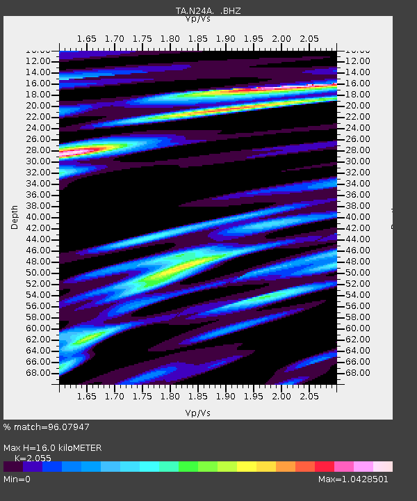
| Estimated Moho Depth: |
16.0 km |
| Estimated Crust Vp/Vs: |
2.06 |
| Assumed Crust Vp: |
6.306 km/s |
| Estimated Crust Vs: |
3.069 km/s |
| Estimated Crust Poisson's Ratio: |
0.34 |
|
| Radial Match: |
96.07947 % |
| Radial Bump: |
400 |
| Transverse Match: |
85.02644 % |
| Transverse Bump: |
400 |
| SOD ConfigId: |
2622 |
| Insert Time: |
2010-03-06 00:27:23.084 +0000 |
| GWidth: |
2.5 |
| Max Bumps: |
400 |
| Tol: |
0.001 |
|
Signal To Noise
| Channel | StoN | STA | LTA |
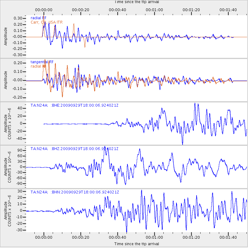
| TA:N24A: :BHZ:20090929T18:00:06.924021Z | 15.236836 | 3.2284943E-6 | 2.1188744E-7 |
| TA:N24A: :BHN:20090929T18:00:06.924021Z | 1.6113439 | 3.851746E-7 | 2.3903934E-7 |
| TA:N24A: :BHE:20090929T18:00:06.924021Z | 2.0813434 | 5.570034E-7 | 2.6761722E-7 |
| Arrivals |
| Ps | 2.7 SECOND |
| PpPs | 7.6 SECOND |
| PsPs/PpSs | 10 SECOND |


