You are here: Home > Network List > LD - Lamont-Doherty Cooperative Seismographic Network Stations List
> Station BRNJ Basking Ridge, New Jersey > Earthquake Result Viewer
BRNJ Basking Ridge, New Jersey - Earthquake Result Viewer

| Earthquake location: |
Peru-Ecuador Border Region |
| Earthquake latitude/longitude: |
-4.1/-80.4 |
| Earthquake time(UTC): |
2017/06/05 (156) 11:34:11 GMT |
| Earthquake Depth: |
51 km |
| Earthquake Magnitude: |
5.6 Mww |
| Earthquake Catalog/Contributor: |
NEIC PDE/us |
|
| Network: |
LD Lamont-Doherty Cooperative Seismographic Network |
| Station: |
BRNJ Basking Ridge, New Jersey |
| Lat/Lon: |
40.68 N/74.57 W |
| Elevation: |
50 m |
|
| Distance: |
44.9 deg |
| Az: |
6.271 deg |
| Baz: |
188.237 deg |
| Ray Param: |
0.071499884 |
| Estimated Moho Depth: |
30.75 km |
| Estimated Crust Vp/Vs: |
2.02 |
| Assumed Crust Vp: |
6.283 km/s |
| Estimated Crust Vs: |
3.114 km/s |
| Estimated Crust Poisson's Ratio: |
0.34 |
|
| Radial Match: |
84.80167 % |
| Radial Bump: |
400 |
| Transverse Match: |
57.043873 % |
| Transverse Bump: |
400 |
| SOD ConfigId: |
13570011 |
| Insert Time: |
2019-04-28 03:41:00.524 +0000 |
| GWidth: |
2.5 |
| Max Bumps: |
400 |
| Tol: |
0.001 |
|
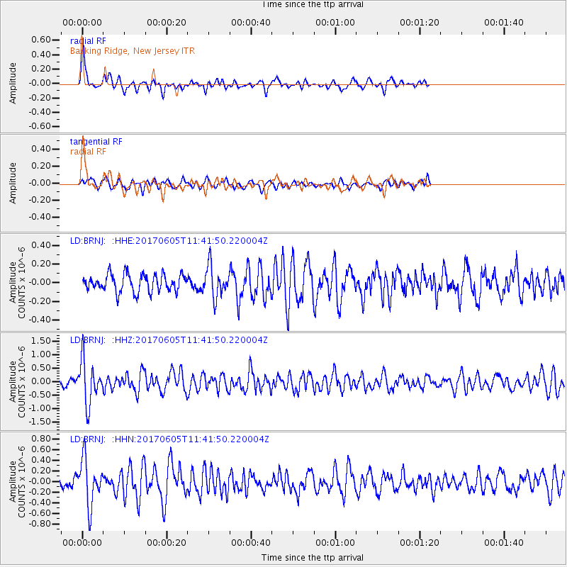
Signal To Noise
| Channel | StoN | STA | LTA |
| LD:BRNJ: :HHZ:20170605T11:41:50.220004Z | 5.399603 | 8.0621135E-7 | 1.4930937E-7 |
| LD:BRNJ: :HHN:20170605T11:41:50.220004Z | 3.6912682 | 4.3751217E-7 | 1.18526245E-7 |
| LD:BRNJ: :HHE:20170605T11:41:50.220004Z | 1.8349057 | 1.7110685E-7 | 9.325103E-8 |
| Arrivals |
| Ps | 5.3 SECOND |
| PpPs | 14 SECOND |
| PsPs/PpSs | 19 SECOND |


