You are here: Home > Network List > LD - Lamont-Doherty Cooperative Seismographic Network Stations List
> Station GEDE Greenville, DE, USA > Earthquake Result Viewer
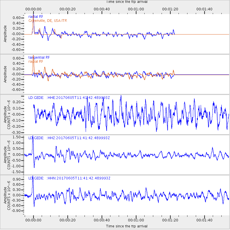
GEDE Greenville, DE, USA - Earthquake Result Viewer
*The percent match for this event was below the threshold and hence no stack was calculated.
| Earthquake location: |
Peru-Ecuador Border Region |
| Earthquake latitude/longitude: |
-4.1/-80.4 |
| Earthquake time(UTC): |
2017/06/05 (156) 11:34:11 GMT |
| Earthquake Depth: |
51 km |
| Earthquake Magnitude: |
5.6 Mww |
| Earthquake Catalog/Contributor: |
NEIC PDE/us |
|
| Network: |
LD Lamont-Doherty Cooperative Seismographic Network |
| Station: |
GEDE Greenville, DE, USA |
| Lat/Lon: |
39.81 N/75.64 W |
| Elevation: |
105 m |
|
| Distance: |
43.9 deg |
| Az: |
5.274 deg |
| Baz: |
186.836 deg |
| Ray Param: |
$rayparam |
*The percent match for this event was below the threshold and hence was not used in the summary stack. |
|
| Radial Match: |
67.752716 % |
| Radial Bump: |
330 |
| Transverse Match: |
65.311066 % |
| Transverse Bump: |
400 |
| SOD ConfigId: |
13570011 |
| Insert Time: |
2019-04-28 03:41:05.355 +0000 |
| GWidth: |
2.5 |
| Max Bumps: |
400 |
| Tol: |
0.001 |
|
Signal To Noise
| Channel | StoN | STA | LTA |
| LD:GEDE: :HHZ:20170605T11:41:42.489993Z | 6.459836 | 5.743031E-7 | 8.890367E-8 |
| LD:GEDE: :HHN:20170605T11:41:42.489993Z | 4.707484 | 3.724468E-7 | 7.9118024E-8 |
| LD:GEDE: :HHE:20170605T11:41:42.489993Z | 1.8131121 | 1.3899496E-7 | 7.666099E-8 |
| Arrivals |
| Ps | |
| PpPs | |
| PsPs/PpSs | |


