You are here: Home > Network List > N4 - Central and EAstern US Network Stations List
> Station 553A Crawfordville, FL, USA > Earthquake Result Viewer
553A Crawfordville, FL, USA - Earthquake Result Viewer
| Earthquake location: |
Peru-Ecuador Border Region |
| Earthquake latitude/longitude: |
-4.1/-80.4 |
| Earthquake time(UTC): |
2017/06/05 (156) 11:34:11 GMT |
| Earthquake Depth: |
51 km |
| Earthquake Magnitude: |
5.6 Mww |
| Earthquake Catalog/Contributor: |
NEIC PDE/us |
|
| Network: |
N4 Central and EAstern US Network |
| Station: |
553A Crawfordville, FL, USA |
| Lat/Lon: |
30.19 N/84.43 W |
| Elevation: |
16 m |
|
| Distance: |
34.3 deg |
| Az: |
353.776 deg |
| Baz: |
172.825 deg |
| Ray Param: |
0.07767874 |
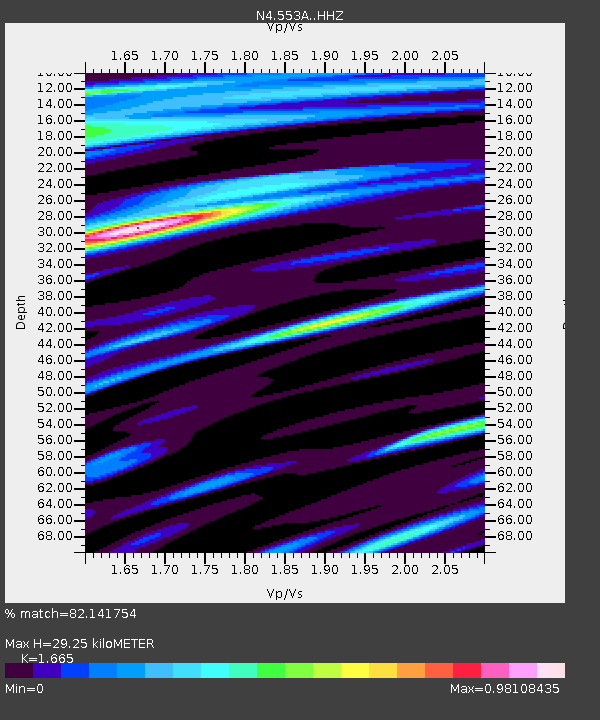
| Estimated Moho Depth: |
29.25 km |
| Estimated Crust Vp/Vs: |
1.66 |
| Assumed Crust Vp: |
6.347 km/s |
| Estimated Crust Vs: |
3.812 km/s |
| Estimated Crust Poisson's Ratio: |
0.22 |
|
| Radial Match: |
82.141754 % |
| Radial Bump: |
386 |
| Transverse Match: |
69.91088 % |
| Transverse Bump: |
400 |
| SOD ConfigId: |
13570011 |
| Insert Time: |
2019-04-28 03:41:42.261 +0000 |
| GWidth: |
2.5 |
| Max Bumps: |
400 |
| Tol: |
0.001 |
|

Signal To Noise
| Channel | StoN | STA | LTA |
| N4:553A: :HHZ:20170605T11:40:22.560Z | 7.46075 | 1.2079425E-6 | 1.6190631E-7 |
| N4:553A: :HHN:20170605T11:40:22.560Z | 4.085804 | 5.8947904E-7 | 1.4427492E-7 |
| N4:553A: :HHE:20170605T11:40:22.560Z | 1.6656917 | 2.4569928E-7 | 1.4750587E-7 |
| Arrivals |
| Ps | 3.3 SECOND |
| PpPs | 11 SECOND |
| PsPs/PpSs | 15 SECOND |


