You are here: Home > Network List > N4 - Central and EAstern US Network Stations List
> Station T42B Van Buren, MO, USA > Earthquake Result Viewer
T42B Van Buren, MO, USA - Earthquake Result Viewer
| Earthquake location: |
Peru-Ecuador Border Region |
| Earthquake latitude/longitude: |
-4.1/-80.4 |
| Earthquake time(UTC): |
2017/06/05 (156) 11:34:11 GMT |
| Earthquake Depth: |
51 km |
| Earthquake Magnitude: |
5.6 Mww |
| Earthquake Catalog/Contributor: |
NEIC PDE/us |
|
| Network: |
N4 Central and EAstern US Network |
| Station: |
T42B Van Buren, MO, USA |
| Lat/Lon: |
37.03 N/91.09 W |
| Elevation: |
165 m |
|
| Distance: |
42.1 deg |
| Az: |
347.191 deg |
| Baz: |
163.958 deg |
| Ray Param: |
0.07322801 |
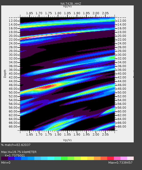
| Estimated Moho Depth: |
19.75 km |
| Estimated Crust Vp/Vs: |
1.74 |
| Assumed Crust Vp: |
6.53 km/s |
| Estimated Crust Vs: |
3.759 km/s |
| Estimated Crust Poisson's Ratio: |
0.25 |
|
| Radial Match: |
82.62037 % |
| Radial Bump: |
282 |
| Transverse Match: |
62.095257 % |
| Transverse Bump: |
400 |
| SOD ConfigId: |
13570011 |
| Insert Time: |
2019-04-28 03:42:58.731 +0000 |
| GWidth: |
2.5 |
| Max Bumps: |
400 |
| Tol: |
0.001 |
|

Signal To Noise
| Channel | StoN | STA | LTA |
| N4:T42B: :HHZ:20170605T11:41:28.079989Z | 5.39559 | 4.1742655E-7 | 7.73644E-8 |
| N4:T42B: :HHN:20170605T11:41:28.079989Z | 4.968705 | 2.5082704E-7 | 5.048137E-8 |
| N4:T42B: :HHE:20170605T11:41:28.079989Z | 2.8419454 | 1.1541449E-7 | 4.0611084E-8 |
| Arrivals |
| Ps | 2.4 SECOND |
| PpPs | 7.7 SECOND |
| PsPs/PpSs | 10 SECOND |


