You are here: Home > Network List > TA - USArray Transportable Network (new EarthScope stations) Stations List
> Station N24A Carr, CO, USA > Earthquake Result Viewer
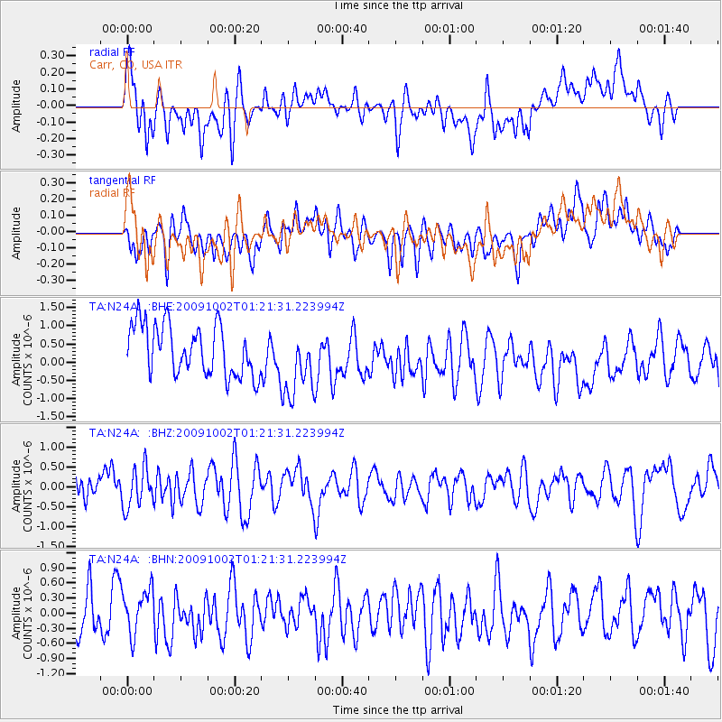
N24A Carr, CO, USA - Earthquake Result Viewer
*The percent match for this event was below the threshold and hence no stack was calculated.
| Earthquake location: |
Tonga Islands |
| Earthquake latitude/longitude: |
-16.2/-173.5 |
| Earthquake time(UTC): |
2009/10/02 (275) 01:09:26 GMT |
| Earthquake Depth: |
10 km |
| Earthquake Magnitude: |
5.5 MB |
| Earthquake Catalog/Contributor: |
WHDF/NEIC |
|
| Network: |
TA USArray Transportable Network (new EarthScope stations) |
| Station: |
N24A Carr, CO, USA |
| Lat/Lon: |
40.83 N/104.88 W |
| Elevation: |
1695 m |
|
| Distance: |
85.1 deg |
| Az: |
45.156 deg |
| Baz: |
243.833 deg |
| Ray Param: |
$rayparam |
*The percent match for this event was below the threshold and hence was not used in the summary stack. |
|
| Radial Match: |
48.94245 % |
| Radial Bump: |
400 |
| Transverse Match: |
50.09536 % |
| Transverse Bump: |
400 |
| SOD ConfigId: |
2622 |
| Insert Time: |
2010-03-06 00:28:47.650 +0000 |
| GWidth: |
2.5 |
| Max Bumps: |
400 |
| Tol: |
0.001 |
|
Signal To Noise
| Channel | StoN | STA | LTA |
| TA:N24A: :BHZ:20091002T01:21:31.223994Z | 0.94387543 | 5.0457504E-7 | 5.34578E-7 |
| TA:N24A: :BHN:20091002T01:21:31.223994Z | 0.79217863 | 4.4336988E-7 | 5.596842E-7 |
| TA:N24A: :BHE:20091002T01:21:31.223994Z | 1.4095341 | 9.630472E-7 | 6.8323794E-7 |
| Arrivals |
| Ps | |
| PpPs | |
| PsPs/PpSs | |


