You are here: Home > Network List > TA - USArray Transportable Network (new EarthScope stations) Stations List
> Station N24A Carr, CO, USA > Earthquake Result Viewer
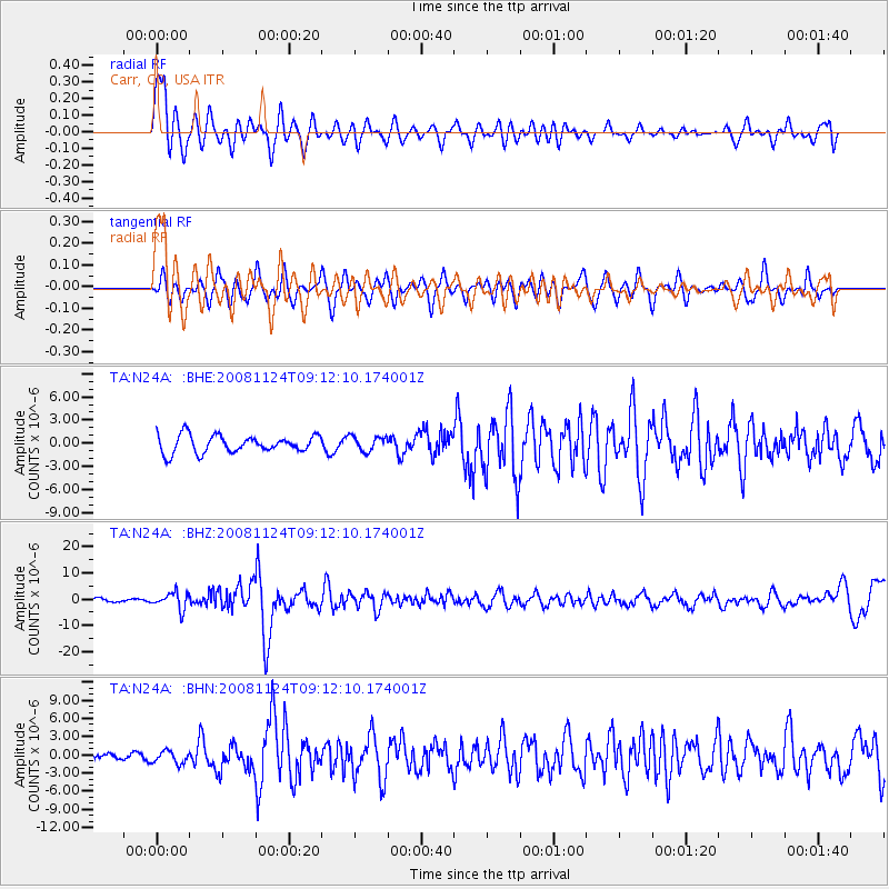
N24A Carr, CO, USA - Earthquake Result Viewer
*The percent match for this event was below the threshold and hence no stack was calculated.
| Earthquake location: |
Sea Of Okhotsk |
| Earthquake latitude/longitude: |
54.2/154.3 |
| Earthquake time(UTC): |
2008/11/24 (329) 09:02:58 GMT |
| Earthquake Depth: |
492 km |
| Earthquake Magnitude: |
6.5 MB, 7.3 MW, 7.3 MW |
| Earthquake Catalog/Contributor: |
WHDF/NEIC |
|
| Network: |
TA USArray Transportable Network (new EarthScope stations) |
| Station: |
N24A Carr, CO, USA |
| Lat/Lon: |
40.83 N/104.88 W |
| Elevation: |
1695 m |
|
| Distance: |
63.7 deg |
| Az: |
56.273 deg |
| Baz: |
319.917 deg |
| Ray Param: |
$rayparam |
*The percent match for this event was below the threshold and hence was not used in the summary stack. |
|
| Radial Match: |
76.743065 % |
| Radial Bump: |
390 |
| Transverse Match: |
61.06745 % |
| Transverse Bump: |
400 |
| SOD ConfigId: |
2658 |
| Insert Time: |
2010-03-06 00:28:58.496 +0000 |
| GWidth: |
2.5 |
| Max Bumps: |
400 |
| Tol: |
0.001 |
|
Signal To Noise
| Channel | StoN | STA | LTA |
| TA:N24A: :BHZ:20081124T09:12:10.174001Z | 5.414788 | 3.1135585E-6 | 5.750103E-7 |
| TA:N24A: :BHN:20081124T09:12:10.174001Z | 2.2935288 | 1.0437931E-6 | 4.551035E-7 |
| TA:N24A: :BHE:20081124T09:12:10.174001Z | 0.86459243 | 9.612669E-7 | 1.1118151E-6 |
| Arrivals |
| Ps | |
| PpPs | |
| PsPs/PpSs | |


