You are here: Home > Network List > TA - USArray Transportable Network (new EarthScope stations) Stations List
> Station N24A Carr, CO, USA > Earthquake Result Viewer
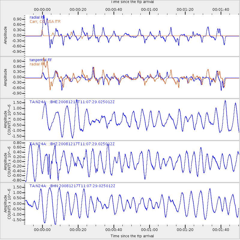
N24A Carr, CO, USA - Earthquake Result Viewer
*The percent match for this event was below the threshold and hence no stack was calculated.
| Earthquake location: |
Fiji Islands Region |
| Earthquake latitude/longitude: |
-17.7/-178.4 |
| Earthquake time(UTC): |
2008/12/17 (352) 10:55:59 GMT |
| Earthquake Depth: |
530 km |
| Earthquake Magnitude: |
5.8 MW, 5.2 MB, 5.8 MW |
| Earthquake Catalog/Contributor: |
WHDF/NEIC |
|
| Network: |
TA USArray Transportable Network (new EarthScope stations) |
| Station: |
N24A Carr, CO, USA |
| Lat/Lon: |
40.83 N/104.88 W |
| Elevation: |
1695 m |
|
| Distance: |
89.5 deg |
| Az: |
46.684 deg |
| Baz: |
246.029 deg |
| Ray Param: |
$rayparam |
*The percent match for this event was below the threshold and hence was not used in the summary stack. |
|
| Radial Match: |
62.382133 % |
| Radial Bump: |
400 |
| Transverse Match: |
54.015312 % |
| Transverse Bump: |
386 |
| SOD ConfigId: |
2658 |
| Insert Time: |
2010-03-06 00:29:18.758 +0000 |
| GWidth: |
2.5 |
| Max Bumps: |
400 |
| Tol: |
0.001 |
|
Signal To Noise
| Channel | StoN | STA | LTA |
| TA:N24A: :BHZ:20081217T11:07:29.025012Z | 0.7519292 | 3.552032E-7 | 4.7238916E-7 |
| TA:N24A: :BHN:20081217T11:07:29.025012Z | 2.175469 | 1.1981689E-6 | 5.5076345E-7 |
| TA:N24A: :BHE:20081217T11:07:29.025012Z | 0.21004125 | 1.8930878E-7 | 9.012933E-7 |
| Arrivals |
| Ps | |
| PpPs | |
| PsPs/PpSs | |


