You are here: Home > Network List > TA - USArray Transportable Network (new EarthScope stations) Stations List
> Station N24A Carr, CO, USA > Earthquake Result Viewer
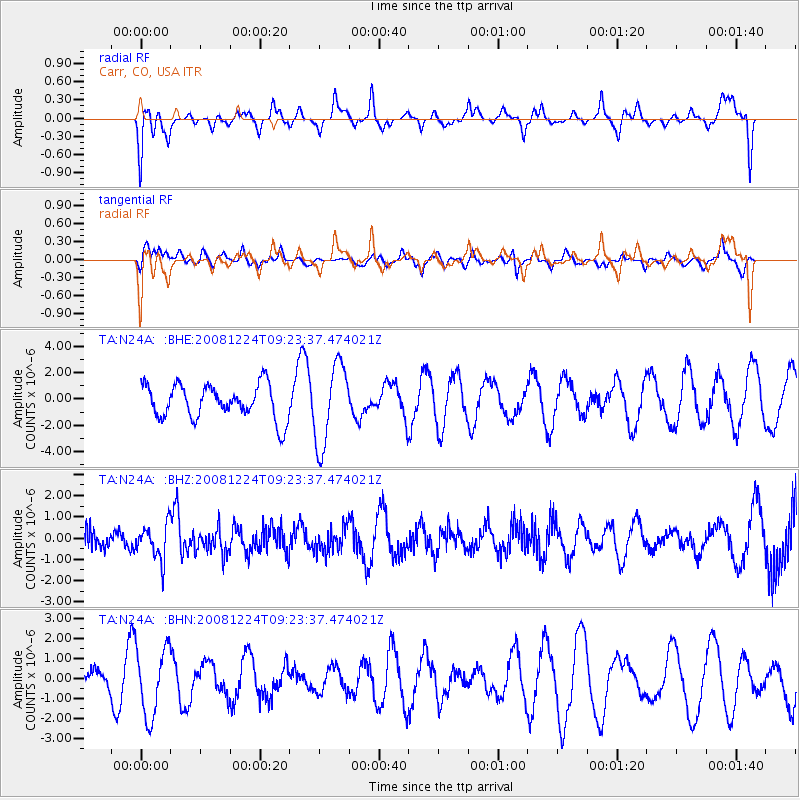
N24A Carr, CO, USA - Earthquake Result Viewer
*The percent match for this event was below the threshold and hence no stack was calculated.
| Earthquake location: |
Tonga Islands Region |
| Earthquake latitude/longitude: |
-17.3/-171.9 |
| Earthquake time(UTC): |
2008/12/24 (359) 09:11:34 GMT |
| Earthquake Depth: |
9.0 km |
| Earthquake Magnitude: |
5.9 MB, 5.6 MS, 6.0 MW, 6.0 MW |
| Earthquake Catalog/Contributor: |
WHDF/NEIC |
|
| Network: |
TA USArray Transportable Network (new EarthScope stations) |
| Station: |
N24A Carr, CO, USA |
| Lat/Lon: |
40.83 N/104.88 W |
| Elevation: |
1695 m |
|
| Distance: |
84.8 deg |
| Az: |
44.551 deg |
| Baz: |
242.035 deg |
| Ray Param: |
$rayparam |
*The percent match for this event was below the threshold and hence was not used in the summary stack. |
|
| Radial Match: |
49.81139 % |
| Radial Bump: |
400 |
| Transverse Match: |
40.048298 % |
| Transverse Bump: |
400 |
| SOD ConfigId: |
2658 |
| Insert Time: |
2010-03-06 00:29:28.996 +0000 |
| GWidth: |
2.5 |
| Max Bumps: |
400 |
| Tol: |
0.001 |
|
Signal To Noise
| Channel | StoN | STA | LTA |
| TA:N24A: :BHZ:20081224T09:23:37.474021Z | 1.2123892 | 8.2488197E-7 | 6.803771E-7 |
| TA:N24A: :BHN:20081224T09:23:37.474021Z | 3.6377413 | 1.6984992E-6 | 4.6691036E-7 |
| TA:N24A: :BHE:20081224T09:23:37.474021Z | 2.4004328 | 3.0881629E-6 | 1.2865025E-6 |
| Arrivals |
| Ps | |
| PpPs | |
| PsPs/PpSs | |


