You are here: Home > Network List > TA - USArray Transportable Network (new EarthScope stations) Stations List
> Station N23A Red Feather Lakes, CO, USA > Earthquake Result Viewer
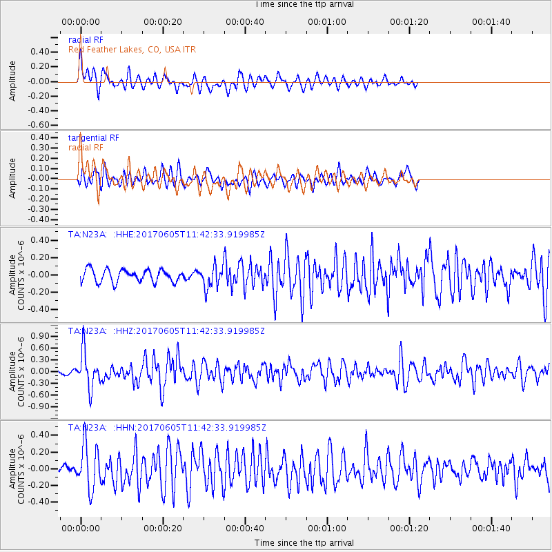
N23A Red Feather Lakes, CO, USA - Earthquake Result Viewer
*The percent match for this event was below the threshold and hence no stack was calculated.
| Earthquake location: |
Peru-Ecuador Border Region |
| Earthquake latitude/longitude: |
-4.1/-80.4 |
| Earthquake time(UTC): |
2017/06/05 (156) 11:34:11 GMT |
| Earthquake Depth: |
51 km |
| Earthquake Magnitude: |
5.6 Mww |
| Earthquake Catalog/Contributor: |
NEIC PDE/us |
|
| Network: |
TA USArray Transportable Network (new EarthScope stations) |
| Station: |
N23A Red Feather Lakes, CO, USA |
| Lat/Lon: |
40.89 N/105.94 W |
| Elevation: |
2458 m |
|
| Distance: |
50.5 deg |
| Az: |
334.928 deg |
| Baz: |
146.111 deg |
| Ray Param: |
$rayparam |
*The percent match for this event was below the threshold and hence was not used in the summary stack. |
|
| Radial Match: |
65.34047 % |
| Radial Bump: |
400 |
| Transverse Match: |
54.7011 % |
| Transverse Bump: |
400 |
| SOD ConfigId: |
13570011 |
| Insert Time: |
2019-04-28 03:46:52.271 +0000 |
| GWidth: |
2.5 |
| Max Bumps: |
400 |
| Tol: |
0.001 |
|
Signal To Noise
| Channel | StoN | STA | LTA |
| TA:N23A: :HHZ:20170605T11:42:33.919985Z | 7.446479 | 4.615325E-7 | 6.197997E-8 |
| TA:N23A: :HHN:20170605T11:42:33.919985Z | 4.094694 | 2.7520193E-7 | 6.720939E-8 |
| TA:N23A: :HHE:20170605T11:42:33.919985Z | 1.7199577 | 1.2608673E-7 | 7.330804E-8 |
| Arrivals |
| Ps | |
| PpPs | |
| PsPs/PpSs | |


