You are here: Home > Network List > TA - USArray Transportable Network (new EarthScope stations) Stations List
> Station Z18A Geronimo, AZ, USA > Earthquake Result Viewer
Z18A Geronimo, AZ, USA - Earthquake Result Viewer
| Earthquake location: |
Fiji Islands Region |
| Earthquake latitude/longitude: |
-20.7/-177.4 |
| Earthquake time(UTC): |
2007/10/08 (281) 18:37:53 GMT |
| Earthquake Depth: |
338 km |
| Earthquake Magnitude: |
5.6 MB, 5.7 MW, 5.6 MW |
| Earthquake Catalog/Contributor: |
WHDF/NEIC |
|
| Network: |
TA USArray Transportable Network (new EarthScope stations) |
| Station: |
Z18A Geronimo, AZ, USA |
| Lat/Lon: |
33.09 N/110.04 W |
| Elevation: |
812 m |
|
| Distance: |
83.6 deg |
| Az: |
51.235 deg |
| Baz: |
240.399 deg |
| Ray Param: |
0.045196652 |
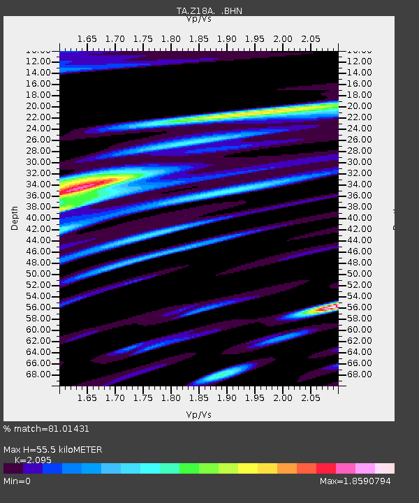
| Estimated Moho Depth: |
55.5 km |
| Estimated Crust Vp/Vs: |
2.10 |
| Assumed Crust Vp: |
6.276 km/s |
| Estimated Crust Vs: |
2.996 km/s |
| Estimated Crust Poisson's Ratio: |
0.35 |
|
| Radial Match: |
81.01431 % |
| Radial Bump: |
400 |
| Transverse Match: |
70.3418 % |
| Transverse Bump: |
400 |
| SOD ConfigId: |
2564 |
| Insert Time: |
2010-03-06 00:29:59.549 +0000 |
| GWidth: |
2.5 |
| Max Bumps: |
400 |
| Tol: |
0.001 |
|

Signal To Noise
| Channel | StoN | STA | LTA |
| TA:Z18A: :BHN:20071008T18:49:13.575Z | 0.9142359 | 2.9645088E-7 | 3.2426084E-7 |
| TA:Z18A: :BHE:20071008T18:49:13.575Z | 1.5284336 | 3.979348E-7 | 2.6035465E-7 |
| TA:Z18A: :BHZ:20071008T18:49:13.575Z | 4.3514113 | 1.0639011E-6 | 2.4449562E-7 |
| Arrivals |
| Ps | 9.9 SECOND |
| PpPs | 27 SECOND |
| PsPs/PpSs | 37 SECOND |


